The front or west side of Browns Canyon National Monument protects the Arkansas River Canyon while allowing lots of development in all but the canyon proper. The east side is a Wilderness Study area with no development and access only by foot or horseback. Often these wilderness areas are great for wildlife viewing since they see much lower visitor traffic and typically require a long hike through front country to access. Here, it looks like we can drive a back route to a remote trailhead and jump right in. We are going to check it out.
Its forecast to be 93F today and we should have gotten a bit earlier start but the trail is in the national forest so we anticipate some pretty good shade and its just 30 some miles to the trailhead. We should be ok.
Just out of Salida we start dirt road. It is a bit narrow and quite twisty but good dirt road as we wander past the vacation homes built above town. Settlement stops and the road condition deteriorates. It is narrower and rougher and twistier as we wind our way around a quarry. It is all county routes and with each number change the road seems a bit less frequently maintained. We come upon a mountain town, Turret. Every single side street has big no trespassing and private property sign with warning to stay on the county route. All other property is overseen by the Turret HOA. Stay out. Ok, we stay to our route and carry on. Now we are definitely on the road less traveled. Brush is encroaching from both sides and wildflowers share the two-track path. Drainage is accomplished by cutting a ditch across the road and loose rock is strewn across steep climbs. We pass through sandy sections and many sections too steep to see the road over the hood or so tight a turn there is no way to tell if any one is coming. Turns out that isn’t a problem. We don’t meet another vehicle anywhere along the narrow route. Our little truck is in low gear 4-wheel drive but doing all that Kent asks of it. We are about 8 miles out what we think will be 10 miles of terrible road when, silence. The truck just shuts off. OMG, what’s that about. We still wonder; but it started right up like nothing happened. Whew! Ultimately washouts and steep roadcuts make it impassable. Kent backs to a wide spot and we hike in what turns out to be the last ¼ mile to the trailhead.
This is why we came here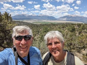 , a walk through wild space with hopes of seeing deer maybe elk and maybe even bear. It is rugged and beautiful as we move along first an old two track road then dry stream beds. Granite monoliths rise high above us with pinon pine and juniper in the valleys between them. We do notice there is not much shade and that the trail is often soft sand underfoot. Neither is what we were expecting. We manage to get off trail following the path of what must have been a trail ride. We wind up trailblazing up and down three ridges and their associated troughs. It’s getting hot and we are a bit tired and exasperated at the difficulty finding the trail. One more climb and tada, we are back on the trail and heading for high ground where we find fantastic long mountain views out over the valley to surrounding 14000s. We are feeling the heat and elevation so cut the hike a bit short and head back. So far one cottontail and a couple chipmunks. Good thing the views were nice.
We take quite a few breaks but make it safely to the truck. Retrace our route along the backcountry roads. Head on back to camp and collapse in the air conditioning.
Overall. It is a beautiful, quiet hike. The drive out to the trailhead is probably too much. If you do go, you definitely do not want to do it on a 90+ day in the brilliant sun. And don’t forget your hat.
Iron Teepee
“Living our Dreams”
