Kluane National Park

Sheep Mountain trail

We actually saw as many sheep from the visitor center parking lot as from the trail but it is still a beautiful walk.  We climbed high enough to get a good view of the river valley, glaciers, and the snow capped St Elias mountain peaks.  It is reportedly a major bear corridor.   We saw lots of digs where they had gone after roots or ground squirrels but not so much as a track or scat.  Just to be safe, we did a bit of singing to the bears along the way.

The scuttlebutt was right.

The Alaska Highway in this corner of the Yukon is pretty rough road.  They are working on it as we speak but that just makes it messier and progress even slower as we wait for pilot cars and equipment.  Creeping along at about 15 mph lets me do a lot of sightseeing and today it gave us a good look at a big bear (grizzly I think) who was considering crossing the road.

Top of the World Highway

This seasonal road (mostly gravel) runs 108 miles between Dawson City Yukon and Chicken Alaska on the top of the mountains.  The drive winds through pristine wilderness with views of mountain tops and valleys along either side of the road that go on for over 100 miles some of which are still snow covered.  It seems to go on forever. Top of world comp_4438 
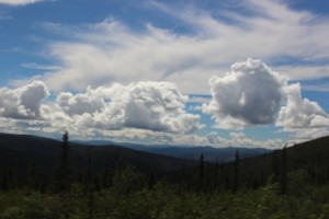
Midway through the trip you cross from Yukon Territory Canada into Alaska at a part time border crossing.  The crossing is only open 12 hours a day during the summer months.

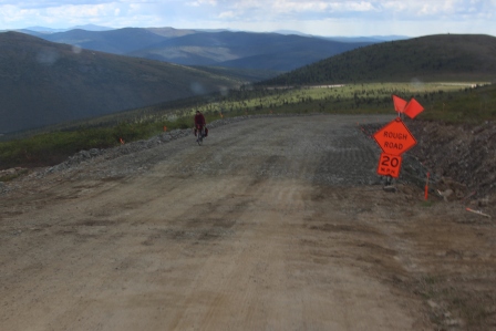
Days ago we heard our first stories about the road construction on the US side.  One visitor center specialist put it in perspective by saying “no has been pulled out by a Euc(earthmover) yet”.  They can still say that, BUT it was 13 miles of driving on road base on the US side Road Constructioncomp_4454
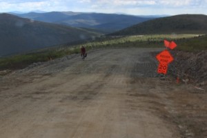
with survey sticks down the center and edge of the road sticking up between 1 inch and 2 ft depending on how much they need to add before they install gravel.  They use 1 to 6 inch crushed stone for base so for a while it was rough and tedious for our travel.  I really had to feel for the motorcycles and bicycles we met trying to bump on through without taking a spill.  We finished the construction portion and stopped for the night at a BLM campground about 15 miles short of Chicken Alaska, 93 miles in 5 hours and worth every minute of it.

Rivers are part of the travel even now

The engine roars and black smoke bellows as the hull grinds against the sandy bank.  The ramp drops, the engine slows to an idle to hold the ferry against shore.  Travelers of all sorts make their exit.  I wait my turn anxiously watching for the go ahead from the ferry operator.  Ok, it’s a go.  I am 7th of 8 and the ramp goes up.  Ferry Comp_4430I wave to Kent.  He has to wait with the motorhome until the next trip.  The engines roar again and the ferry slides out into the current and swings wide downstream.  It is a queasy sort of slipping motion.  The ride is short lived though.  In only minutes we align with the far shore and in one amazing maneuver are safely snug against the bank.  I hung around to watch Kent cross…all went smoothly there too.  We are on our way.

The Yukon Government runs a ferry as an integral part of the highway system.  The ferry  is about 100 feet long and crosses the 1000 ft + wide (with a pretty swift current this time of year) Yukon River at Dawson City for all those heading north and west to Alaska.    Fuel tankers get priority and they make the trip all by themselves.  40 ft class a with toads ride it.  Pick up campers.  Motorcycles.  Even pedestrians.  It is the way to go up here.  It was a fun twist for our travels.

Along the Dempster- answer

It is a culvert heater. They actually need to heat some road culverts during the spring melt to facilitate drainage. The permafrost keeps the culvert frozen while the snow on top is melting and creating lakes along and over the road. We have so far seen electric and steam heaters.

Building on Permafrost

After many years of adjustments and modifications Dawson City YT has determined the best way to build on permafrost is to raise the building up about 3 feet on cribbing and allow the cold air of winter to get under the building, keeping the soil under the building frozen. Seems when you place the building on grade it warms the soil over time and the thawed soil turns into soup and the building sags or heaves with the changes in weather. The cribbing can be adjusted as needed to maintain a level structure. Same thing goes for the sidewalks of Dawson City YT. They are elevated boardwalks and nearly all the streets are dirt/gravel (not paved). Removing your dirty shoes when you get to the library takes some getting used to but, paved streets and sidewalks heave and crack.

I never thought about “TOO Much” sunshine.

We are approaching the summer solstice and we are nearing the Arctic Circle. That means it never gets dark. We came home from a late show in town and at 1:30 am you did not need headlights. Officially Dawson gets about 20 hours of daylight. That means with the twilight, it is always light. Makes it a little hard to sleep. You get to sleep and roll over and it’s daylight, must be time to get up. Not. Oh, BTW if you ever wondered why the Arctic Circle isn’t at an even number, it is defined as the location where the sun does not set on the summer solstice; N 66 degrees 33 minutes.

Dawson City YT, Mining sure left its mark.

On the landscape. For years the isolated pioneer miner crouched streamside with his pan or rocked his sluice box to glean gold dust and the occasional nugget. A few got rich but many just got tired and dirty. Then the word got out that there is gold up here and within only a few years the creeks were filled with highly mechanized equipment. Huge dredges dug their way along stream beds hogging out buckets full of stone and silt, screening out the gold. The discharge end swings as it spills out the debris and leaves a curling trail of rounded boulders and fine glacier silt. Dredge poop. Over the years the silt has been carried away by rains and floods of the mighty Yukon River until all that remains is row upon row of snaking ridges of stones. Placer gold is found up here at the bottom of the alluvial fields left by glaciers. Countless years of erosion released the gold from its original ore and deposited it as a layer. It might wash out in streams to be panned or has to be dug out from under some 20 feet of permafrost. They still mine for gold here: from the lone guy with his pan to the highly automated equipment owned by huge corporations. They do reclaim/restore the landscape a bit nowadays but I suspect in a hundred years folks will see scars left by today’s prospectors as well. Ah, the allure of gold!

On the culture

Miners sure must have been a thirsty lot. Saloons abound. We visited Diamond Tooth Gertie’s Saloon and Gambling Hall. They recreate a dancehall show complete with ruffled skirts and the cancan. Gerties Comp_4351There was lots of audience involvement and some pretty fair singing. We took in a show at The Palace Grand Theatre where the proprietor set out to mine the miners of their newly found wealth. We met Klondike Kate; one of the many dance hall girls of the time who were also often referred to as women of negotiable affection. It seems that miners must get lonely too. One can still stay at Bombay Peggy’s, a brothel gone hotel nowadays. The RCMP brought law and order and safety and sanitation. That’s who the miners had to thank for the requirement to carry 1000 pounds of supplies over the Chilkoot Pass…so supplies were enough for all the new comers to Dawson. Stern wheelers worked the waters of the Yukon and Klondike Rivers along these gold fields too. We toured a shallow draft workhorse of a boat, the SS Keno. No tablecloths or fancy china on this one. Her cargo was typically ore and miners….no frills. I had High Tea at the Commissioner’s house. This was the Territorial Capital back then after all. It is quite the mansion.