We sleep in a little but decide there is time for a quick
hike before we head out for Banff. The
Walk-in-the-Past starts right in camp and tells some of the story of early
railroad times in the valley. At the
trailhead we find a sign “closed to entry”.
The trail that would have led us past railroad wreckage is closed for a
derailment cleanup operation. Hmm, that
is a pretty good indication of what railroading in this valley is all about.
The trek up Paget Lookout trail is a bit of a challenge with
an elevation change of 1,700 ft that brings us to a beautiful 6,928 ft. Early switchbacks make a steep cut through dense
undergrowth so we do a bit of talking to the bears whenever we are not too
winded to do so. It is a great walk we just take it slow
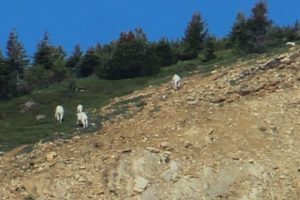
enjoying patches of wildflowers that carpet every sunny clearing. Mountain goats make an appearance on the
slopes across the valley. They are
pretty far away but recognizable. This
hike is really about the view from the top.
The wide braided milky-blue Kicking Horse River winds it way down the long
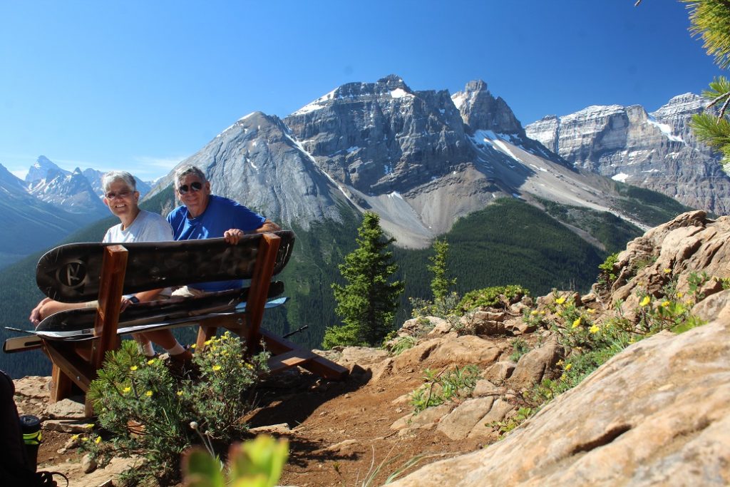
valley between steep treed slopes with snow-capped peaks towering above. It is impressive. Some anonymous soul built a bench using snow
boards complete with a photo image of Emerald Lake Lodge. It is perfectly placed. We hang out at the top for an hour.
A side trail takes us to Sherbrooke Lake perched up a side
valley cut by the Sherbrooke River. We
cross plank bridges. Lush vegetation hugs
the trail’s edge and encircles the glacial lake then gives way to talus slopes and
finally bare rock peaks. A solitary
loon floats, preening, silent, not too worried about visitors. We rest for a spell basking in the quiet. Both Sherbrooke and Emerald are beautiful
lakes but something is lost when the crowds get too big. I prefer Sherbrooke by far even if it is (maybe
because it is) harder to get to.
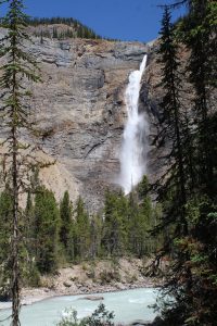
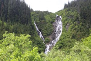
First, we are off to Takakkaw Falls. It is the tallest falls in Western Canada,
nearly 800 feet and it is running full today fed by silt laden glacier
meltwater. It is beautiful. The access road has a section of steep
switchbacks that larger vehicles actually have to back down a section to make the
turns. Kent has flashbacks from our last
trip out here and is once again grateful that we are in the car not the
motorhome let alone the motorhome and trailer.
We stroll and relax on a perfectly placed park bench.
It is peak tourist season here and lots of the natural
attractions have very little parking so we hang out in camp a while waiting for
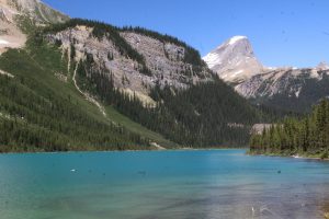
crowds to thin out then head for Emerald Lake.
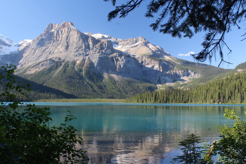
Sunlight bouncing off the fine glacier flour suspended in the lake gives
it a unique green grey color. Bare,
rugged peaks rise high above the wooded shoreline. A loon calls out. It is not a north country lake without
one! A leisurely lap around the lake is
a great ending for the day.
We are up and on the road by 8:30. That will get us to Kicking
Horse Campground in Yoho National early enough to get a first come first serve
site, we hope. There is lots of
construction on the TransCanadian Highway so the drive is a bit stressful and
takes a bit longer than planned. I am
happy, the snow-capped mountains are beautiful. There are more avalanche sheds. Seeing those certainly doesn’t make me want
to be up here in the winter!
We roll into the campground..its 11:30…we crossed time
zones! Too late. Only tent sites ae available. No biggie though, we find a spot just next
door in Monarch Campground and it is just fine.
We even have time to do a bit of exploring yet today.
Did you know? When one is talking glaciers the word névé means, sort of, pre-glacier snow. It is grainy and has been refrozen and just waiting to be compacted to become part of the icefields and ultimately the glacier. This trip is the first time we have seen that term on maps.
It is actually sunny when we get up, 45F but sunny. I will take it. We dawdle over breakfast and it warms up a
few more degrees before we head out to an easy, short local trail, Meeting of the
Waters. Camp is full as is the day use
lot and several large groups funnel toward the main trailhead at the end of
camp. There are lots of trails in this
area though and before long we have our little stretch of woodland to
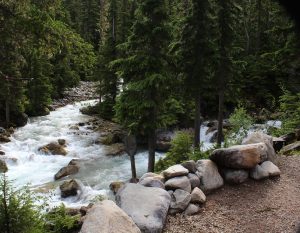
ourselves. It is any easy stroll to a
log bridge just below the junction of two rushing, glacier melt streams, the Illecillewaet
River and Asulkan Brook. High above us the
sun lights up jagged mountaintops, with a fresh dusting of snow, in a brilliant
blue sky dotted with fluffy clouds.
Nice. It spits rain but we are
undaunted and extend our walk along the 1885 trail. We hope for a good view of camp from across the
river but no such luck. I take the opportunity
to scan high meadows and spot a dot…a bear digging up goodies. He is much to far away for a good picture but
with binoculars I am certain it is a bear working across the open field. Just one more excuse for a more high-powered
telephoto lens, right Kent?
Break…we relax in camp a couple hours then head out to join
a ranger led hike.
The hike is on Balu Pass trail. Oh yes, Balu as in the Bear! The trail passes below Grizzly Peak, Ursus
Major, and Ursus Minor through an area of prime bear habitat. It is one of the areas in the national park that
require (as in fine $115 if you don’t) hikers to travel in groups of 4 adults,
minimum. Large groups tend to be noisy
and noisy groups rarely startle bears.
That is good…for hikers and bears.
We meet a pair of hikers who apparently ignored the grouping rule, they are
being escorted down off the trail by an enforcement Warden.
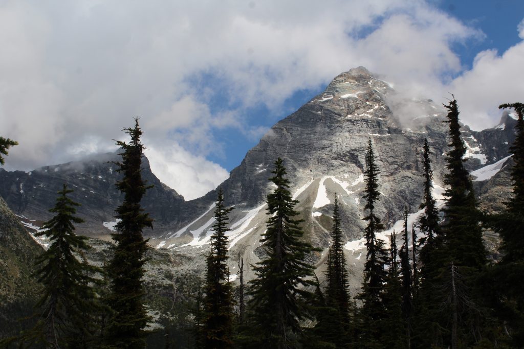
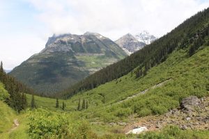
Our Ranger steps pretty lively up the first three switchbacks. Most of us are breathing heavy and we lose a group of about 10 who are expecting more of a stroll than a hike. Still, we are a group of 8 so safely on our way. No great new revelations as to bear habits or behaviors and we don’t actually see any bears but it is still a great walk. These mountains are amazingly steep resulting in impressive avalanche slopes throughout the back country. Bears love the wildflowers and berries that pack these open meadows. We spot hoary marmots basking and playing in a boulder field. We review a bear scratching tree where the Grizzlies rake the bark and leave hair and scent for other bears. Our turn around point is at the base of three impressive waterfalls where snowmelt gracefully spills down the mountainside. The water is about as cold as you might expect…brrr. I would take this walk again. Next time all the way to the end (we went about half way) and next time a little more slowly to check out the wildflowers and give wildlife a bit more time to show itself.
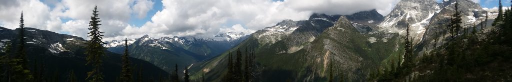
The campground sits in a bowl surrounded by peaks 8500 to
9500 ft with glaciers adorning the high-altitude flanks of many of them. We didn’t climb a peak today but we did hike Glacier
Crest, the ridge formed between the Vaux and the Illecillewaet glaciers. Total, 3 1/2 miles each way with 2700 feet
elevation change.
We wake to overcast skies and by the time we finish
breakfast it is raining. Rats. We wait it out and as the temperature comes
up just a few degrees the rain stops. We
are off. Things start pretty easy as we
head back along the river and cross the milky glacier silt laden stream. A few steps beyond the bridge our trail
branches off and climb begins in earnest.
First it is long steep switchbacks one after another. Just when we think that is tough it devolves
into an even steeper rocky sheep trail that seems to go on forever. Humidity is high in the dense pine forest and
the climb is exhausting. We make a few
stops to rest and to check out the wildflowers and the mountain views. There are spots of blue sky and brilliant
sunlight on the mountain snow caps. Our
journey ends in the boulder field near the top of the ridge where we find a
perfect spot to relax and take in the view.
A pica pokes its head out from among the boulders for just a moment. They are even cuter than marmots. Today
is a good day!
Glacier Crest
Gotta go back down.
The steep grade pounds the knees and loose, uneven rock, and a bit of
mud from the earlier rain, threaten to twist ankles. We are home relaxing with the sun on our faces
and the Illecillewaet River dancing at our feet. Today is indeed good.
Meadows in the Sky Drive is just 25 km but takes you from the
cedar and hemlock forest of the Columbia River valley to an alpine meadow. At the entrance station we are reminded to be
on the watch for bears, they active right now.
Cool! Red, yellow and blue wildflowers
line the steep switchbacks and every direction provides a view of a different
mountain range. The panoramic view from
the top is beautiful but hazy skies and mountain top clouds keep it from being
spectacular. We stroll among patches of
snow and amazing, lots of mosquitoes.
Trails to back country alpine lakes originate up here too but we will
have to save that for another day, it is already after six and the road closes
at 8:30. On the trail back to the car
the clear notes of Thrushes float from the tree tops. Pesky Gray Jays patrol the picnic area.
Some dummy discharged a can of bear spray in the pit
toilet…wow, no wonder the furry fellows run from that stuff! Kent and I cough and sniffle for good half
hour and we didn’t even get it right in the face.
Heading down. No bear
but a good look at an adorable marmot. He
stood up when Kent whistled at him. They
are pretty big but he didn’t look very scary with a blade of grass hanging out
of one corner of his mouth. Very
cute. A bit later a long skinny weasel
looking fellow raised up, maybe a fisher?
I am not sure what he was but he seemed as interested in us as we in
him, then he scurried off. We are home
for a late dinner then off to bed hoping for better weather tomorrow. The forecast is not good.
Next stop Glacier NP but the journey is part of the
fun. Just out of Nakusp we spot a huge
raft of logs on Arrow Lake. Looks like
that is how they bring timber from the west side, they float it across. That time-proven lumbering practice is alive
and well here. We motor on heading for
one of the great rural Canada travel phenomena, the car ferry. Highways just end at one side of a lake or
river and resume on the far side one short boat ride away. Before long we add to the que on the approach
road; motorhomes, lumber trucks (they don’t float it all across it seems),
motorcycles, a horse trailer, and the usual cars and trucks. We have time to kill so I head for the bank
to watch the ferry come in from the far side of the lake. It is huge (later I see a placard indicating
1,500 tons max gross weight). Loading
begins, trucks and motorhomes to the center and cars and pickups on the outside
lanes. We look tiny next to a full load
of cedar logs! It is smooth sailing so
we get out to snap a few pictures and in just 20 minutes we are back on the
highway. Even with a bunch of
construction on Canada 1 we make it to Glacier NP and Illecillewaet Campground
before noon where Kent finds a great site right on the Illecillewaet River. Sweet.
I check out the afternoon program all about early female mountain
climbers. It is a great story as the
women not only took on the challenges of the mountains but also the men of their
time. Afterall, mountain climbing isn’t
very lady-like and certainly can’t be done right in a skirt.
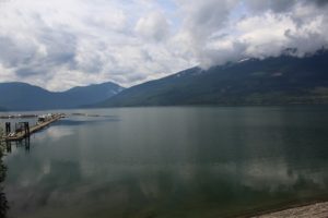
Nakusp makes a pretty good stop to do a little exploring of
this rugged country. We start easy, the paved
lakefront walk along the shore of Arrow Lake right in town. Saddle Mountain rises high above Arrow lake
where scattered kayaks, canoes and the occasional power boat slice through the
still water. I spy an ice cream shop where
I relax in the sun with an English toffee milk shake and Kent his hot fudge
sundae.
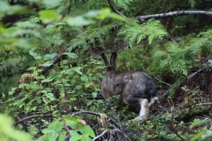
A bit more challenging, a nature trail through lush cedar
forest. It has more elevation change
than we expected and is intertwined with cross country ski loops resulting in a
few minor navigational errors; still, the walk is peaceful and enjoyable. We spot a summer colored snowshoe rabbit…check
out the telltale big feet.
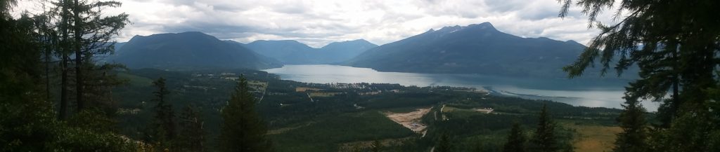
Today’s biggest challenge, 1200ft elevation change on a steep/really steep mile to a lookout, Vicki’s View, above town and the lake. Overcast skies and a bit of haze mute the colors but the view is still worth the walk.
One more stop, Burton City Cidery. This place is way off the beaten path but I
just have to check it out. The base
cider is dry and not very sweet. I try
almost every offering: Apple-ginger is a
bit over powering, Apple-berry versions just don’t quite suit. I skipped the one with added hops – definitely
not my thing. I come home with a 2-liter growler of my
favorite, Apple-n-Rye, Rye whiskey barrel aged apple cider. I am going to try not to drink it all before
the kids come visit.