From atop the mesa we saw the Grand Valley of the Colorado River. Today we head into the valley to check out The Colorado National Monument and all that the Grand Junction area has to offer. The forecast is for blistering heat, triple digits most days, so we know exploring is going to have to happen early in the day. I get a C in geography today. I had to look up why it is called the western slope. Dah, the western side of the Continental Divide. Not to be confused with the eastern side that they call The Front Range. Ok.
We settle in at Saddlehorn campground near the highest elevations of the monument. It is a nice view over the valley but not high enough to get much of a break from the mid-day heat. We check out the visitor center and make an initial pass along Rim Rock Drive through what is a small version of the big red-rock Utah parks. There are colossal and intricate monoliths, windows and towering cliffs. The route takes us down into the valley. We have been having a hankering for Colorado beef so we head for a local favorite, Cattleman’s Bar and Grill in nearby Loma. Turns out it is actually at the cattle auction barn….kind of a rustic setting but pleasant and welcoming. We go for steak of course, Kent a sirloin and I prime rib. Both are seasoned nicely and perfectly prepared as ordered. Kent’s is actually more tender but mine is quite good as well. I have to try the peach cobbler (Palisades is right here and they are known for excellent peaches). Glad I tried it, a bit cakier than I expected but delicious. We leave with a giant doggie bag, portions are huge. 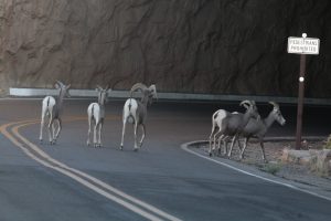 We have a bit of excitement on the way home. A band of big horn sheep appears in the roadway just at the exit of one of the rock tunnels on Rim rock Drive. They cross and seemingly fly up a nearly vertical cut to the flatland above the road. What a great way to end the day.
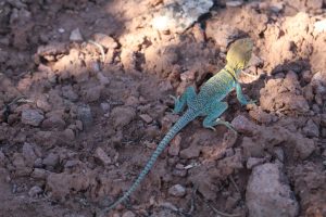
Collared Lizard
It’s 5:30AM, a beautiful, cool morning. A quick breakfast and we are at the Lower Monument Canyon trailhead by 6:30. Combining Lower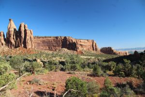 Monument with Wedding Canyon trail we make a 5-mile loop into the central canyon to the foot of Independence Monument. It is a bit of a climb passing red rock, pinion pine and juniper. Flycatchers and black throated sparrows flit and chip around us. An amazingly acrobatic swift evades repeated swoops of a pursuing hawk high above the cliff tops. Near the half way mark, oncoming hikers let us know that there are big horn sheep in the valley just ahead.
 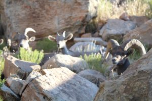 Wonderful. Around the next turn we find first a band of ewes and young then spot an older male with impressive horns. Across the trail a regal looking old fellow sits quietly along with a ewe and two young. They all watch cautiously but continue to munch and mill around the area. We move on leaving them to find their site to bed down for the heat of the day. Beyond Independence Monument we spot a ewe and one lamb. Great walk. It’s 90 by the time we leave the trail around 10:30. We are glad we got an early start.
I’ve been planning a stop at the Dream Café. It is a local bakery in town and not far out of our way. They claim to have the biggest, best cinnamon rolls in town and we feel like we earned one. We end up actually having brunch there and have to take the cinnamon roll home in a doggie bag. We hang out in camp for the rest of the afternoon and evening. I take in the ranger program, The symphony of the Monument. It is a fun talk about the significance of soundscapes and the importance of protecting them as well as the visual landscapes of parks.
Next, a day in town. We sleep in then head for a local candy shop, Enstrom’s. Their claim to fame is Almond Toffee and it is fantastic. We hang out watching them make candy cooking it in big copper pots, pouring it to cool on a refrigerated table, smoothing, coating with chocolate and then with ground almonds. Teams of two work at four tables along with another 3 or so floating among them to support measuring, cleaning and charging the copper pots. All synchronized. They make a lot of toffee. I sample the toffee and we both sample store made ice cream. Now it is time for errands: haircuts and laundry. We finish up in time to spend the rest of the hot afternoon at a movie, Indiana Jones. It took me a beat just to figure out how to buy tickets. It’s all touch screen now and most are set up just to scan the prebought ticket on one’s phone. I get to the right touchscreen and find the show, choose two tickets then get a seating chart. Did I want to upgrade my seats? Geeze, I just want to see a movie. I get it figured out and we find our seats…not sure there could be a bad one or one to pay a premium for in this small theater. But hey, we are happy with ours. The movie is really just a giant rehash of all the best chase and fight scenes from past Indiana Jones movies. The plot is pretty lame and predictable; but, for Indiana Jones fans it was a fun couple hours.
Our last day here is very laid back. My one objective, find a fruit market and get some of those highly acclaimed Palisades peaches. The earliest varieties are in season and we find a few ripe and ready to eat at a little family market not far from camp. We select a couple vine ripe tomatoes as well and pay in the honor jar. While we are out, we stock up on groceries. Our next week or so is back out in the boonies in the National Forest. It’s hot when we get home. We kick on the generator and the ac for a couple hours for a lazy afternoon.

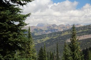 Clouds shroud the top-most peak of Grand Teton but the view is worth the climb. We relax and lunch watching the clouds advance and rise on the mountain tops until it seems wise to head back. Clouds are thickening. We keep a good pace on our return (down-hill always helps with that) and in one check behind us see the very place we had been standing completely shrouded in dark grey clouds. Good timing. We keep moving and make it back to the truck wet with sweat but ahead of the rain.
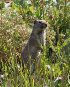 or maybe bear but no such luck. Pika scurried on the scree piles near the top of the hike. We heard but did not see marmots. Kent spotted a different little rodent fellow – might be a prairie dog, at 8,000 ft?
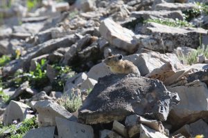
 The pika are working hard collecting flowers and grasses and stacking them in large piles to dry in the sun. This one fellow has two heaps each much bigger than he is.
 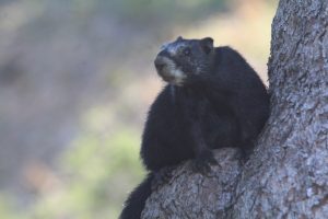 We come upon one nearly black marmot perched in a tree…pretty bear-like isn’t he. The view from the saddle is spectacular as well. We hang for a while just taking it all in and hoping the haze will clear a bit more.
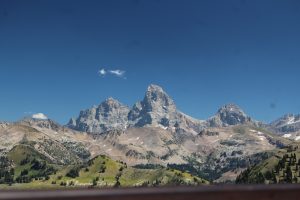 Our ticket is good for as many as 3 trips up and we want to see if it has cleared off. Another smooth ride up and a short walk and we find it, a not-quite-crystal-clear but marvelous view. Well worth the trip back up, especially since we rode the lift back down this time!
 Today, early in the walk, the trail takes us up the walls of the canyon well above the creek bed. The views are lovely as we cross meadows interspersed with treed areas and open rocky outcroppings. We first hear the waterfall exiting the cave then spot the opening in the cliffs above us. The last half mile or so is a steep mix of rock steps and tree root tangle that takes us to just over 8700 feet in elevation. There is a bit of puffing but we make it. Folks claim they scale the slope up to the entrance to walk then crawl to the back of the cave where the opening reduces to a couple feet in each direction. It looks like today water would be running around our feet the whole time.
 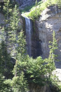 We settle for the gurgle and splash of the falls and the lovely view from below. We scan high meadows for wildlife both going and returning but none make an appearance. Guess there are too many places to hide. It is great to spot whatever is out there but it is even fun to look for them.
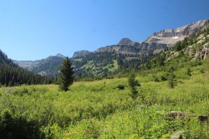 Teton Canyon along the south fork of Teton Creek. We set out along the creek through towering pines with a much lighter understory than other recent hikes. It is cool and lovely. There is a fair amount of traffic on the trail but Kent and I are alone on a stretch and we hear a loud huff.
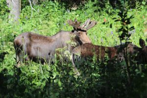 Maybe 100ft to our right along the creek bank are two moose, a mature bull with a good start on a rack and a juvenile. They browse with an eye on us for a bit before moving on when more hikers arrive. We get a good look and some nice pictures. We move on too. Pines give way to wide open mountain meadows backed by majestic cliffs, blanketed with wildflowers, and often cut through by a ribbon of willows lining the banks of smaller streams. We find a perfectly placed butt rock and relax taking in the view.
 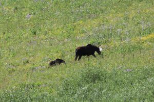 Kent muses that it seems a perfect moose spot and not 5 minutes later a cow moose emerges from the willows moving nervously and even challenging a pair of hikers who are on the trail fairly close. She runs at them, not really charging but seemingly telling them not to get any closer then turns and collects up her young calf that has been hidden along the creek. They both head upslope and disappear into the denser undercover. All is well and it is a great encounter, for US.
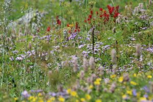 one more lovely meadow and a lunch stop at the intersection with Devils Staircase
 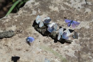 trail before we reverse course for a nearly all downhill stroll back to the trailhead.
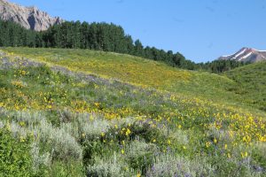 Snodgrass Mountain, head out pretty early for the drive to put us on the trail by 8:30 or so. The area is amazing with entire hillsides painted mostly shades of yellow but dotted with purple, blue, red, white and orange. Snow capped peaks ring the valley along with the namesake crested butte. Wow! We hike about 4 miles through meadows and treed terrain. What a great time of year to be here.
 The pictures don’t do it justice. Two marmots cavort on the rock pile providing lunchtime entertainment. We won’t be finishing the loop drive. We meet a Crested Butte bound driver who reports that some earlier driver overestimated his skills and is stuck in remaining snow pack. They have blocked the road and no one is getting through. So, home we go.
 , a walk through wild space with hopes of seeing deer maybe elk and maybe even bear. It is rugged and beautiful as we move along first an old two track road then dry stream beds. Granite monoliths rise high above us with pinon pine and juniper in the valleys between them. We do notice there is not much shade and that the trail is often soft sand underfoot. Neither is what we were expecting. We manage to get off trail following the path of what must have been a trail ride. We wind up trailblazing up and down three ridges and their associated troughs. It’s getting hot and we are a bit tired and exasperated at the difficulty finding the trail. One more climb and tada, we are back on the trail and heading for high ground where we find fantastic long mountain views out over the valley to surrounding 14000s. We are feeling the heat and elevation so cut the hike a bit short and head back. So far one cottontail and a couple chipmunks. Good thing the views were nice.
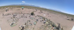 It’s been on my list
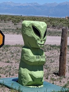
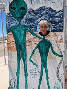
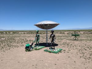
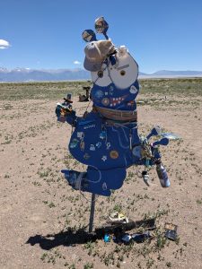 since we got here. What a joke. It is definitely an “anything for a buck” place not the serious sort of alien believers we have found at Roswell and Marfa. Probably worth the $5 each for entertainment value!