There are places to go and things to see

An overlook high on the bluffs above the valley with a great look at Hoodoos and a magnificent view of the meandering Bow River is an easy stroll from camp.  We see our first elk contentedly grazing before we even get out of camp.  We had to cross the road to keep our distance.  Once in the open it is pretty windy but still nice to be out so we extend the walk out through a forested area.  A doe and two fawns make an appearance.  We put in about 3.7 miles our first full day.  Time to chill in camp for the evening.  A Coyote makes its way through the tall grass just beyond our site. 

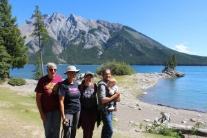
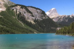
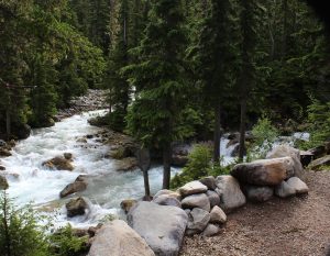
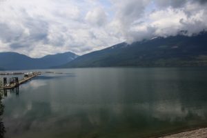
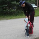
Mountains encircle Lake Minnewanka, beautiful.  Grandpa has Willa in the carrier as we venture out Stewart Canyon trail.  The hike begins high above the creek as it tumbles its way to the lake.  We continue to a place where a side creek allows the kids to get down to the cold snow melt waters.  Willa hangs out with Grandpa and Nana exploring the rocky streambed, snacking, and moving rocks, because they are there.  This is a beautiful quiet place with the smell of pine along with the sight and gurgle of fast-moving water just the right distance away.  Mike shoulders the load heading back to the lake.   We are greeted by a VERY friendly golden mantled ground squirrel as we wrap up our lake time.  It is early, we head into Banff to check out some shops and maybe find a nice café with street-side dining to relax.  We stumble upon a puppet show put on by the National Park.  It is all about stewardship but told through the life of a baby black bear who got separated from its Mom and ultimately reunited.  Willa’s attention is alternately drawn to the puppets and the live ukulele player who stands nearby.  It is well done and lots of fun.  Everyone gets the munchies and we push Friday homemade Pizza night to Saturday and set out in search of a restaurant.  It takes a bit of looking but we settle on Park Distillery.  We find of lots of fun cocktails mixed with their own gin, vodka, and rye and sample a few.  To our great surprise, they also have a pretty broad vegan menu….winner all around.  It is a lovely end to a great day.            

Despite a questionable forecast we pack up to head for Boom Lake. Next camping trip Willa will have her own pack, she tried Mom’s today but it’s a bit too much!

Boom Lake

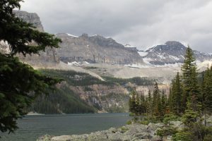
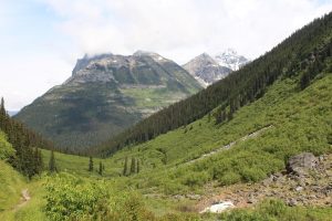
The trail includes a fair amount of uphill but not too taxing then opens up onto a beautiful alpine lake ringed by mountains with a large section of grey boulder, talus slope.  Bright sun would have made the view perfect but it isn’t to shabby even on this grey cool day.  We soak in the beauty, lunch, and relax until the clouds start to spit.  Tracy bundles Willa up like a little cocoon and she naps against Mike’s back as we head back to the trailhead.  Thunder in the distance and periods of pretty heavy rain urge us to make better time then our stroll out to the lake.  We are glad for the warm dry car after 6.8-mile roundtrip.       

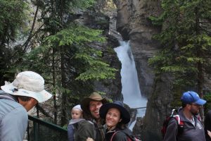
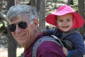
Johnson Canyon trail is a signature hike for Banff park.  They see a million visitors on this trail every year and we know it’ll be a zoo but we just have to see it.  Our plan is to go on out to ink pots with the anticipation that crowds will thin out as the distance and difficulty increase.  Even with a pretty early start we are turned away at the main lot but find parking just ¼ mile up the road.  No problem…Willa is loaded up.  Thanks for the ride Daddy Sherpa.  Let’s go.  It is beautiful…pretty crowded especially at falls overlooks but manageable.  Crowds thin as we move above the top of the falls and we nearly have the trail to ourselves as we move toward the ink pots. There is a lot of uphill!  Trees thin and our view opens up to the broad Johnson Creek upper canyon and the braided flow path of the creek.  Winding paths and foot bridges crisscross between still pools where springs bubble up to form concentric rings in the silty bottoms, the ink pots.   We relax, explore, and lunch before heading back.  Willa put in some more walking miles, checked out wild flowers, and got close but not quite in the cold water.  It is a full day, 8.7 miles round trip, but we are glad we included the quieter stretch out to the ink pots.   Oh yeah, we spotted a grizzly bear on the drive out to the trailhead.  Nice bonus.

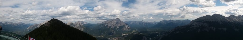
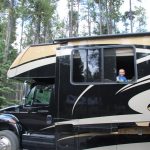
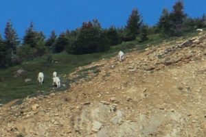
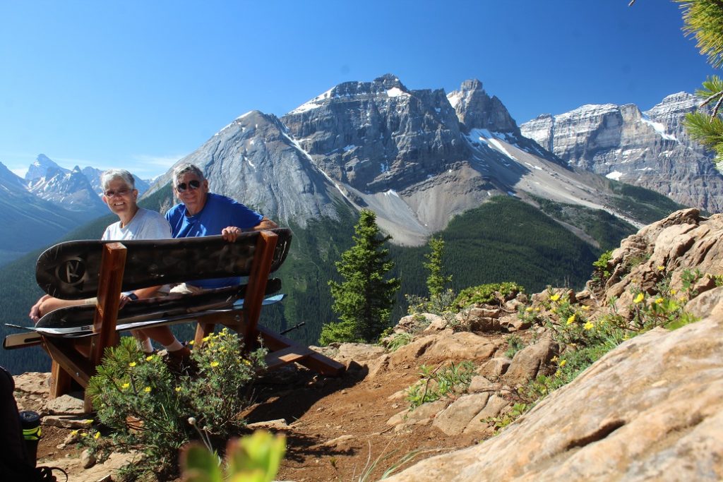
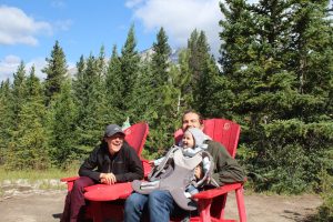
The view from above. Today we take the Banff Gondola up Mt Sulfur.  Wow.  The ride is fun and the view fantastic and includes six different mountain ranges.  We check out the open-air lounge, walk the peak trail, and sample café fare at a sunny table with a wonderful view.  Ewe and baby bighorn sheep make a perfectly timed appearance so we get an up-close look.  Back home, it is hammock time and a chance for a different view of camp; out the MH window.

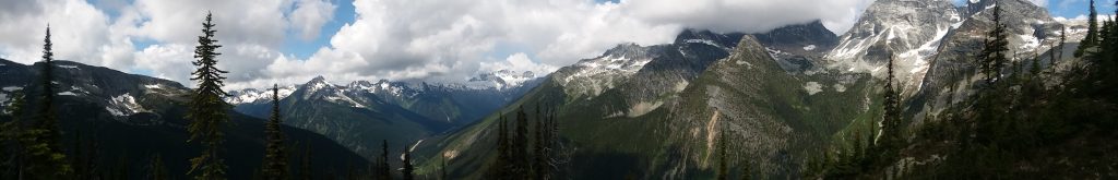
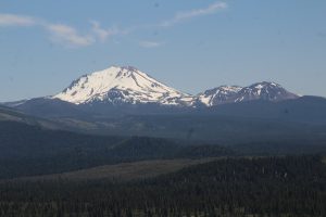
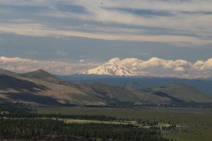
The Icefields Parkway, magnificent views in route to The Icefields Discovery Center and tomorrow’s Columbia Icefields Experience and the Skywalk.  Camp is not exactly a remote pristine natural setting; it is the paved lot at the Icefield Center.  But the view is wonderful and at night when traffic and people noises die down we are within earshot of the cracking and crashing as pieces naturally cleave off the five glaciers that drape the mountains around us.  Plus, it puts us close to the start point of our excursion onto the glacier tomorrow.  We learn about Katabatic winds generated as ice-chilled air slides down off the glaciers and sweeps across the land, we now know that this icefield includes snow dome,

This image has an empty alt attribute; its file name is SnowDome_0845-300x200.jpg

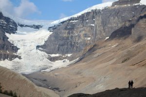
a hydrological apex, which feeds melt water to three oceans (Atlantic, Artic and Pacific), we see unrefutable proof that the earth is warming as evidenced by accelerating retreat of nearly all of the Canadian Rockies glaciers, including the Athabasca glacier we will walk on tomorrow.       

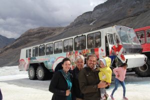
Layer up then load up.  First a bus then this huge crawler that moves across the steep slopes (up to 32 degrees) of moraine then out onto Athabasca Glacier.   The tires are nearly as tall as a person and the ride is a bit rough but it is an exciting start to the journey.   The day is a little grey and the cold wind is howling as we climb out onto the ice.  Yikes, it is cold but we have lots of clothes on and head out to explore.  Willa even has her felt shoe-mittens on!  We adults slowly pick our way across the wet ice as it is slick underfoot but Willa is anxious to move.  We get in some walking, lots of pictures, sample the glacier melt water, and admire the view for a bit.  The cold sinks in as feet are wet and the unsure footing is a bit stressful.  Time to head back to the warmth and relative safety of our huge tired creeper and the next part of the adventure, a skywalk 981 feet above the Sunwapta River nestled among the towering mountains. 

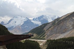
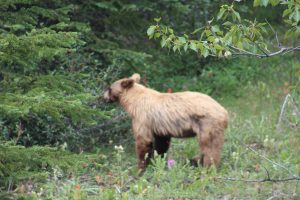
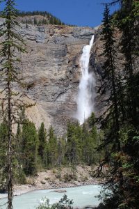
A walkway leads toward a sweeping cantilevered arc over the river valley.  It is lined with signage and a great audio tour that provide lots of info about geology, glaciers, wildlife, and climate.  There are more fantastic views.  We are out of the cold wind plus warmed by the now brightly shinning afternoon sun.  We make it a mostly leisurely stroll with a bit of stress for Tracy.  Heights are not really her thing.  Come to think of it, she has been quite the trooper on that account this entire trip.  Willa alternates napping and checking out the views.     We dawdle on the drive off the icefield parkway.  Willa rides with Grandpa and Nana so Mom and Dad can check out some overlooks and short trails.  Our first surprise, a great look at a grizzly bear enjoying berries.  We stop and watch as he munches contentedly.  Later, big horn sheep make a showing along the roadside.  Mike and Tracy check out Bridal Veil falls.  We picnic at Bow Lake then head on to Cochrane as the kids return flight looms near.  

One last stroll around Yoho

We sleep in a little but decide there is time for a quick hike before we head out for Banff.  The Walk-in-the-Past starts right in camp and tells some of the story of early railroad times in the valley.  At the trailhead we find a sign “closed to entry”.  The trail that would have led us past railroad wreckage is closed for a derailment cleanup operation.  Hmm, that is a pretty good indication of what railroading in this valley is all about.

We pack up and head out. 

We go for the view

The trek up Paget Lookout trail is a bit of a challenge with an elevation change of 1,700 ft that brings us to a beautiful 6,928 ft.  Early switchbacks make a steep cut through dense undergrowth so we do a bit of talking to the bears whenever we are not too winded to do so.   It is a great walk we just take it slow enjoying patches of wildflowers that carpet every sunny clearing.  Mountain goats make an appearance on the slopes across the valley.  They are pretty far away but recognizable.  This hike is really about the view from the top.  The wide braided milky-blue Kicking Horse River winds it way down the long valley between steep treed slopes with snow-capped peaks towering above.  It is impressive.  Some anonymous soul built a bench using snow boards complete with a photo image of Emerald Lake Lodge.  It is perfectly placed.   We hang out at the top for an hour. 

A side trail takes us to Sherbrooke Lake perched up a side valley cut by the Sherbrooke River.  We cross plank bridges.  Lush vegetation hugs the trail’s edge and encircles the glacial lake then gives way to talus slopes and finally bare rock peaks.   A solitary loon floats, preening, silent, not too worried about visitors.  We rest for a spell basking in the quiet.  Both Sherbrooke and Emerald are beautiful lakes but something is lost when the crowds get too big.  I prefer Sherbrooke by far even if it is (maybe because it is) harder to get to.     

Glaciers, they are what makes this place

First, we are off to Takakkaw Falls.  It is the tallest falls in Western Canada, nearly 800 feet and it is running full today fed by silt laden glacier meltwater.  It is beautiful.  The access road has a section of steep switchbacks that larger vehicles actually have to back down a section to make the turns.  Kent has flashbacks from our last trip out here and is once again grateful that we are in the car not the motorhome let alone the motorhome and trailer.  We stroll and relax on a perfectly placed park bench. 

It is peak tourist season here and lots of the natural attractions have very little parking so we hang out in camp a while waiting for crowds to thin out then head for Emerald Lake.  Sunlight bouncing off the fine glacier flour suspended in the lake gives it a unique green grey color.  Bare, rugged peaks rise high above the wooded shoreline.  A loon calls out.  It is not a north country lake without one!  A leisurely lap around the lake is a great ending for the day.            

Finally!

It is actually sunny when we get up, 45F but sunny.  I will take it.  We dawdle over breakfast and it warms up a few more degrees before we head out to an easy, short local trail, Meeting of the Waters.  Camp is full as is the day use lot and several large groups funnel toward the main trailhead at the end of camp.  There are lots of trails in this area though and before long we have our little stretch of woodland to ourselves.  It is any easy stroll to a log bridge just below the junction of two rushing, glacier melt streams, the Illecillewaet River and Asulkan Brook.  High above us the sun lights up jagged mountaintops, with a fresh dusting of snow, in a brilliant blue sky dotted with fluffy clouds.  Nice.  It spits rain but we are undaunted and extend our walk along the 1885 trail.  We hope for a good view of camp from across the river but no such luck.  I take the opportunity to scan high meadows and spot a dot…a bear digging up goodies.  He is much to far away for a good picture but with binoculars I am certain it is a bear working across the open field.  Just one more excuse for a more high-powered telephoto lens, right Kent? 

Break…we relax in camp a couple hours then head out to join a ranger led hike.

The hike is on Balu Pass trail.  Oh yes, Balu as in the Bear!  The trail passes below Grizzly Peak, Ursus Major, and Ursus Minor through an area of prime bear habitat.  It is one of the areas in the national park that require (as in fine $115 if you don’t) hikers to travel in groups of 4 adults, minimum.  Large groups tend to be noisy and noisy groups rarely startle bears.  That is good…for hikers and bears.  We meet a pair of hikers who apparently ignored the grouping rule, they are being escorted down off the trail by an enforcement Warden.  

Our Ranger steps pretty lively up the first three switchbacks.  Most of us are breathing heavy and we lose a group of about 10 who are expecting more of a stroll than a hike.  Still, we are a group of 8 so safely on our way.  No great new revelations as to bear habits or behaviors and we don’t actually see any bears but it is still a great walk. These mountains are amazingly steep resulting in impressive avalanche slopes throughout the back country.   Bears love the wildflowers and berries that pack these open meadows.  We spot hoary marmots basking and playing in a boulder field.  We review a bear scratching tree where the Grizzlies rake the bark and leave hair and scent for other bears.  Our turn around point is at the base of three impressive waterfalls where snowmelt gracefully spills down the mountainside.  The water is about as cold as you might expect…brrr.    I would take this walk again.  Next time all the way to the end (we went about half way) and next time a little more slowly to check out the wildflowers and give wildlife a bit more time to show itself.            

Ok, we are tired now

The campground sits in a bowl surrounded by peaks 8500 to 9500 ft with glaciers adorning the high-altitude flanks of many of them.  We didn’t climb a peak today but we did hike Glacier Crest, the ridge formed between the Vaux and the Illecillewaet glaciers.  Total, 3 1/2 miles each way with 2700 feet elevation change.

We wake to overcast skies and by the time we finish breakfast it is raining.  Rats.  We wait it out and as the temperature comes up just a few degrees the rain stops.  We are off.  Things start pretty easy as we head back along the river and cross the milky glacier silt laden stream.  A few steps beyond the bridge our trail branches off and climb begins in earnest.  First it is long steep switchbacks one after another.  Just when we think that is tough it devolves into an even steeper rocky sheep trail that seems to go on forever.  Humidity is high in the dense pine forest and the climb is exhausting.  We make a few stops to rest and to check out the wildflowers and the mountain views.  There are spots of blue sky and brilliant sunlight on the mountain snow caps.  Our journey ends in the boulder field near the top of the ridge where we find a perfect spot to relax and take in the view.  A pica pokes its head out from among the boulders for just a moment.  They are even cuter than marmots.   Today is a good day! 

Glacier Crest

Gotta go back down.  The steep grade pounds the knees and loose, uneven rock, and a bit of mud from the earlier rain, threaten to twist ankles.  We are home relaxing with the sun on our faces and the Illecillewaet River dancing at our feet.  Today is indeed good.    

Strolls, hikes, and tastings

Nakusp makes a pretty good stop to do a little exploring of this rugged country.  We start easy, the paved lakefront walk along the shore of Arrow Lake right in town.  Saddle Mountain rises high above Arrow lake where scattered kayaks, canoes and the occasional power boat slice through the still water.  I spy an ice cream shop where I relax in the sun with an English toffee milk shake and Kent his hot fudge sundae. 

A bit more challenging, a nature trail through lush cedar forest.  It has more elevation change than we expected and is intertwined with cross country ski loops resulting in a few minor navigational errors; still, the walk is peaceful and enjoyable.  We spot a summer colored snowshoe rabbit…check out the telltale big feet.

Today’s biggest challenge, 1200ft elevation change on a steep/really steep mile to a lookout, Vicki’s View, above town and the lake.  Overcast skies and a bit of haze mute the colors but the view is still worth the walk.

One more stop, Burton City Cidery.  This place is way off the beaten path but I just have to check it out.  The base cider is dry and not very sweet.  I try almost every offering:  Apple-ginger is a bit over powering, Apple-berry versions just don’t quite suit.  I skipped the one with added hops – definitely not my thing.   I come home with a 2-liter growler of my favorite, Apple-n-Rye, Rye whiskey barrel aged apple cider.  I am going to try not to drink it all before the kids come visit.

First signs of Spring at Paradise Meadow

Boot steps are nearly silent on the needle covered trail a we make a slow climb through thick stand of pines.  (One would think that if trailheads are at 5000 ft + at least some trails would be downhill or at least flat – not so far!).  Patches of snow cling in sheltered spots in the woods. We had been forewarned there was still heavy snow cover on the trail just 2 weeks ago and we find the first on the trail at about ½ mile in.  We are across it in just a few steps.  No big deal.  Split log bridges, fallen logs, and stepping stones aide multiple crossings of first a tiny stream and later the larger Hat Creek.  Bird songs occasionally punctuate the forest silence.  Snow patches become larger and more frequent.  There is a bit more detouring and a lot more careful stepping but it is still passable.  We rest a spell beside a Hat Creek waterfall then find our way to the trail destination. Paradise Meadow. 

The creek meanders across a broad meadow backed by rocky cliffs.  Even ¾ snow covered it is a beautiful serene place.  We scan for wildlife and I check out birds then find a sunny place to settle and soak it all in.  Sounds mingle.  Shadows and colors play off one another as the grays of winter make way for the bright colors of spring.  Cold wind off the snow blasts in stark contrast against my sun warmed skin. The details meld together to create a unique feel for the place.  It is beautiful now and will surely be splendid when the wildflowers come into full bloom…a few more weeks.    

We take a detour at a fork in the trail in search of a vantage point that allows us to keep watch on the meadow while basking in the sun.  We cross a split log bridge that has seen better days.  The heavy snowpack has taken a toll; hope it holds together for our return trip!  Wildflowers are popping up in sun warmed forest glades.  It is a beautiful continuation of our walk but doesn’t bring us back around to the meadow.  We bask in the view for a bit then start back.  As we near the last curve in the trail we hear the telltale sound of an ax wielded by pretty ambitious hands.  Could it be someone working on the bridge, our only path out.   Sure enough; a trail crew is hacking away at the bridge.  They have thought it through though and let us pass on the one still mostly sound log.  Looks like it will all be good as new by the end of the day.  The crew reports that this one was less than two years old….guess Mother Nature wins pretty much all the time!    

We end our stay at Lassen with a stroll around the Lilly Pond trail.  At only ½ mile and close to the visitor center you might be tempted to skip it but it is a nice walk with a well written nature guide.

Did you know: if you sniff the bark on the trunk of a Ponderosa Pine it smells like vanilla!

This is a volcano

Erosion alters and forest cover camouflages the classic volcanic shapes of many of the peaks around Mt Lassen but our hike today is unmistakably volcanic.  We climb Cinder Cone at Butte Lake on the north side of the park. 

First hint, enormous ridges of volcanic boulders deposited over thousands of years, most recently just 370 years ago.  At the trailhead, our feet crunch on the sharp, black grains of volcanic sand.  To our left, a long wall of jumbled rock, now named the Fantastic Lava Bed, that is the cooled remains of slow flowing A’a lava that escaped from low on the cone.  

Black sand is several inches deep now and we are slowly climbing.  The forest abruptly stops and before us is a steep trail cut into the side of the 35-degree cinder cone

This image has an empty alt attribute; its file name is CinderConeProfile_9563-300x200.jpg
Inside the CinderCone

. This will take a while!  The steep angle and deep loose rock make for tough going but we make it.  From a height of 850 feet above the surrounding forest the view is impressive.   Check it out: Fantastic lava Field, Painted Dunes, Mt. Lassen, Butte Lake, Snag Lake, and a dozen other peaks that are remnants of the violent volcanic past of the area.

Painted Desert

Just because, we decide to take the back trail down off the cone.  Yikes, we thought he up-slope trail was bad but this one is even steeper and loose rock deeper than boot tops.  We make a semi-controlled decent as we ride mini avalanches down the first section of the trail.  We manage to stop to admire amazing wildflowers and are greatly relieved to arrive at a more manageable slope on the lower trail.  We stop to empty sharp rocks from our boots then make our way on to the trailhead. 

It is hard work but I definitely recommend the hike.  Take your time and take lots of water.  Kent says walking sticks are a great idea too.

On our way to the hike a rare Sierra Nevada Red Fox crossed the road in front of us and a doe with two very tiny spotted fawns made an appearance along the forest route.               

As we head toward home we check out a National Forest overlook with a great view of the two most prominent mountains: Lassen and Shasta.  It is spectacular.  Note to self, this would be a great place for dark skies viewing of the milky way.   

Mt Lassen 10 miles
Mt Shasta 60 Miles