We start with a guided bird walk. The path is around the very same lake we
strolled yesterday but with a bit of help we spy three new birds: Hermit
warbler, White Headed Woodpecker, and a MacGillivray’s Warbler, plus we see a
total of three bufflehead families. An
eagle made another showing but not so regal this time. He was being chased off by a lone, tiny (but
obviously brazen) black bird. Kent got
some nice reflection pics.
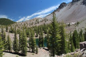
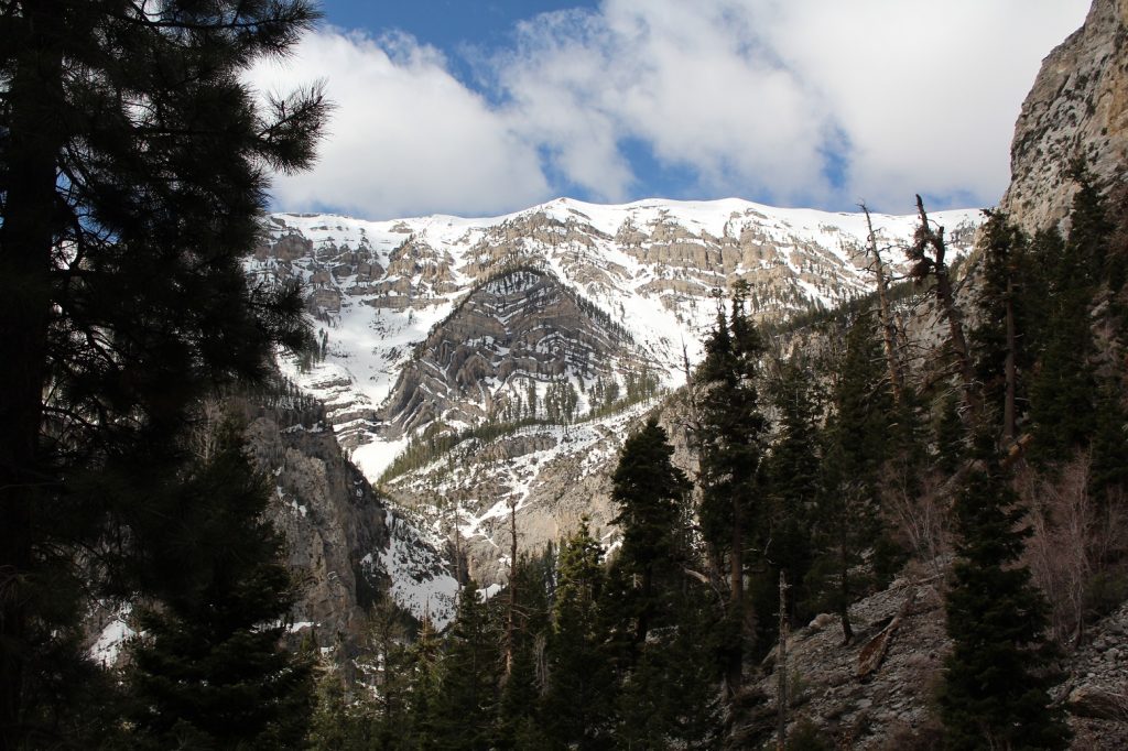
Crags Lake
It is still early so we take off on the Chaos Crags
Trail. We start along a creek winding
through pine forest climbing ever higher. We pass by boulders scattered among the trees
left behind by retreating glaciers or spewed forth from thundering
volcanoes. This is rugged territory
still scared by the long-ago eruptions. Our destination is Crags Lake perched among
the volcanic rubble at about 7000 feet.
The pine scented air is cool and the sun blazes down in the forest
meadows. It is a perfect day for a
walk.
We break out into the open with views of the crags and rocky slopes and the tree encircled, emerald green lake nestled in a low spot before us. Lovely.
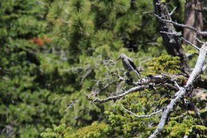
The
unique terrain is the highlight of the walk but some wildlife makes a
showing. We spot a deer and a handful of
the usual wood warblers plus the entertaining, noisy Clark’ s Nutcracker.
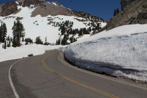
The route through Lassen Volcanic National Park just opened
last weekend, June 22. This area of the
Cascades got 133% of the normal annual snowfall and Spring is arriving
late. The bummer part: probably 2/3 of
the trails are still snow covered and impassable without special gear; which we
do not have.
The upside: scenery is wonderful.
In sunny forest meadows there are bursts of color as
wildflowers erupt along the edge of the retreating snowpack. Brilliant white patches of snow provide
accents in the rugged terrain of volcanic rock and a blanket of rich green pines
making the ordinarily magnificent even more awe inspiring.
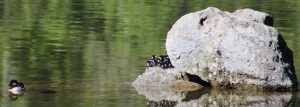
A stroll around Manzanita Lake leads us through dense forest
where the quiet is interrupted only by the chatter of birds overhead, along a
babbling creek, and beside the crystal-clear waters where mother ducks and
grebes and ever vigilant coots call out in alarm to warn of our presence. Black tail mule deer keep a watchful eye on
us as we pass. We spot the regal silhouette
of a Bald Eagle. There are tiny
bufflehead ducks – we learn later that they are one or two days old – huddled
in a pile on a boulder out in the lake.
Mom is patrolling nearby.
The drive through Lassen brings spectacular mountain views,
smelly sulfur geothermal features, a snow-covered meadow cut through by a
meandering stream, glacier blue waters of the thawing alpine lakes, and
thundering creeks swollen with snowmelt.
This is a pretty good place to slide back into the great
outdoors.
We have marveled at the presence of snow-capped Mt. Charleston
towering above Vegas and the seemingly endless desert that surrounds it. Today we head up for a closer look. The forecast is not great, rain by mid-day,
but here we go. In the fifty or so miles
we climb from 1800 ft to 8400 ft elevation as cactus gives way to pine shrouded
mountains. The thermometer dips to 37F
at one point. Glad we brought fleece and
jackets and; yes, it was a good idea to wear long pants! Before the day is over, we will have wished we
had brought gloves.
We head out on a trail to Mary Jane Falls. Early on we are passed by a firefighter who
reminds us, rain forecast for 11AM. It is
pretty well marked yet we manage to wander off along one of the many social
trails inherent in these heavy use, urban area parks. The last ¼ mile of the trail feels more like
hiking up the streambed, turns out it was.
The sound of falling water guides us.
A bit winded and having shed much of our warm gear, we make it to the falls. Four rivulets of snow-melt cascade from the
cliff tops. It is no Niagara but pretty
impressive for these environs. Locals we
encounter say it’s the most water they have seen on the falls. They also say that two weeks ago we would
have found deep snow at the foot of the falls.
Today we find only traces of it in sheltered areas. Most of it has retreated to higher elevation
and creates beautiful contrast in the rugged terrain. Rest. Breathe in the pine scented air. Absorb the calmness. Very nice.
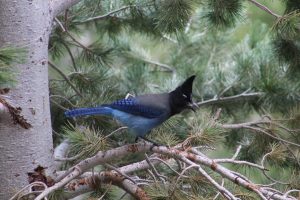
Ok, back down. We take the actual trail down. It is a bit longer with lots of switchbacks but infinitely better underfoot that the streambed. We meet a group of Marine trainees who are heading up to the falls, and they overtake us as we make our way down. We take our time birdwatching and admiring the view. We are greeted by a Stellars Jay. We are mindful of the forecast though. The first drops hit at about 11:15. We pick up the pace and dash to the car just as it begins in earnest.
We check out the Visitor Center. It has this fantastic window clinger of
desert to high mountain terrain. It nearly
goes un-noticed with the naked eye but with a polarized viewer bright colors jump
out. It actually shows the seasons as
you rotate the viewer. I want one of
these in our cabin!
There are many more trails but they will have to wait for
another/drier day. We take the scenic
drive out but by now it is raining hard and clouds are making their way down
the mountain obscuring views and hiding any wildlife from our view. I think we will be back. It seems mid May and mid-week is a good
time. Snow is off many of the trails,
crowds are not too bad and, the snow melt feeds the many falls.
We are a bit hesitant to head out on a trail but the sky is
brightening and it looks like there is a hole in the radar image…we have a few
hours. We head out a wash in search of a
redrock arch. Despite several versions
of trail description, we never actually find the arch. The mountain views are fantastic and
wildflowers and lizards decorate the landscape around our feet. Just as we return to the car rain drops dot
the windshield. Perfect timing.
By the time we return to camp the weather apps are putting out
flash flood warnings for just south of the area we hiked.
It is all about the view.
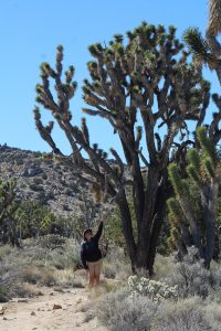
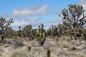
We wander through an amazing stand of Joshua Trees on Teutonia Peak trail. The trees are huge and beautifully branched
more like a maple or an oak than a yucca plant.
It seems that Cima Dome, a smooth even bulge in the desert that is about
10 miles across, provides the perfect habitat for these odd plants. From our perch on rocks near Teutonia Peak, we
gaze at rugged mountain ranges in the distance with the carpet of Joshua trees
at our feet. It is worth the walk, even
at a chilly 45F and strong winds.
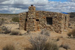
Since we are out, we head for Rock Spring Trail where a natural spring provides year-round water, a very rare thing in the desert and a great place to look for wild life. It means more rough dirt road but we get there fine and I love the rock house at the trailhead. Check it out….it needs a bit of work but would be a pretty cool place to chill out. It is a nice walk out to the spring, more of a seep right now, but no critters to be found. Perhaps it would be better near evening but this place is a little to difficult to get around in to be out wandering after dark.
It is a short drive to our next stop, Hole in The wall
Campground in the southern section of the preserve. Rugged mountain ranges cut through the long
stretches of creosote dominated desert.
We settle in then head for the visitor center since they are closed Tues
and Wed and I always like to check in with them to see if there is anything
special going on during our stay. It is
a bit of an adventure since we set out on the shorter path; 38 miles rather
than 60 miles. The catch, 16 of those 38
are on dirt road. There is a lot of pot
hole dodging and washboard rattling and we are grateful we were not here a
couple weeks ago when they got all the big rain. The road must have been impassable
then. I enjoy the views as Kent endures
the drive. We make our stop then come
home via the paved roads. It wasn’t a
mistake but it is a decision we probably won’t make again! Back home we are entertained by the many
black tailed jackrabbits that scurry around the wash just outside our window.
There is no power in or even near the campground so it is a
great night sky park – once the neighbors put out their huge bonfire. We even got up in the middle of the
night. We are “only” 70 miles from
Vegas so that light dome is visible but Kent still captures some pretty amazing
views. I just stand in the stillness and
soak it all in. The only interruption is
the low call of great horned owls.
The trailhead for our day 1 trail, Barber Peak, is right
here in camp. We dawdle a bit ‘til the temperature
gets into the 50s then head out. Much of
the trail crosses open range where favorite shaded areas are noticeably dotted
with cow flops. Lots of flops but no cows so far. We travel washes and cross low rocky ridges
as we circle along magnificent cliffs.
Erosion patterns are amazing. In
just 6 miles we cross desolate desert and comparatively lush mountainside
slopes. We are on the lookout for big
horn sheep (again) but find only two cows and an adorable calf. We know where at least some of the freshest
flops have come from.
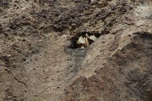
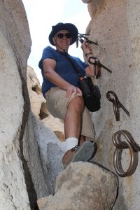
Our trail intersects The Ring Loop Trail. It is sort of the name sake of the area as it
winds through narrow slots (holes in the wall) in the eroded cliffs. We spot a high eroded recess that is filled
with honeycomb – so that is where they live out here! Two of the canyon slots are steep walled and
high enough to warrant climbing rings to assist the ascent. It is a fun trail….as long as you approach it
clockwise so it is up the rings not down them.
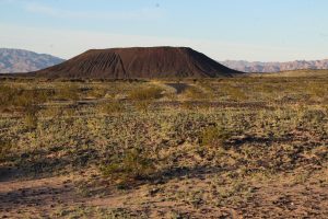
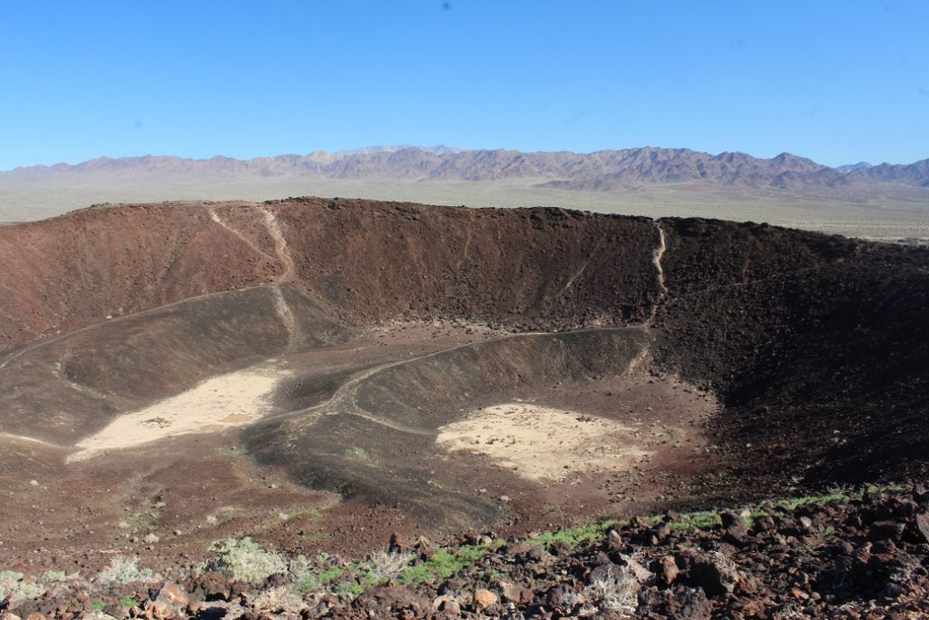
We laze around camp waiting for it to cool off then head for the trailhead about 4PM. Oops, it is a 2 ½ mile trail, if you go down into the crater and who wouldn’t, and it gets dark here by 6PM. We know that it is a rocky uneven climb so not something we want to finish in the dark. New plan, we will hike it tomorrow morning then head on to Mojave Preserve. The overflow lot is a perfect place to boondock. We do a lot of train watching. This big valley seems to be a staging area for the many east-west trains that move through this part of the country. They were lined up like huge caterpillars as we came into the valley and I am sure that one moved through here every half hour all evening and most of the night. We got in some great dark sky star viewing.
Monday morning the temperature is about right and the sun
beautiful but the wind is going to make an exposed hike on the cinder cone rim
an interesting event. We are up for
it. Up close, even the lava flow area
doesn’t seem quite so barren. There are
wildflowers, lizards including chuckwalla and a beautifully colored green -blue
lizard plus more of our usual desert birds.
The ascent up the one trail is loose rock and steep…I regret wearing
shorts. Fractured and wind eroded lava
and pumice make for pretty abrasive stuff that will create some pretty severe
trail rash. We climb up, down through
the crater, back up a really awful trail to the rim, walk about half the rim
with only a few stops when the wind threatened to blow us off, back into the
crater – another trail that is steep and loose rock- then back to the lava
field. I can’t help but imagine the
power involved when this erupted. It must
have been amazing and they claim it was only 500 years ago.
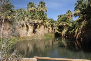
The San Andreas Fault line runs through the Indio Hills in
the Coachella Valley just southwest of Joshua Tree NP. Slo-mo movement along those faults has
created some impressive geologic changes in this part of the country and gets
blamed for lots of damage to man-made structures. In this desert land it is also responsible
for strings of palm trees and even surface pools as water works its way up
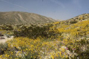
through the fault line. Just beyond the
pool and palm oasis the valley walls and washes are blanketed with wildflowers.
Snowcapped peaks create a perfect back drop. All this is protected in the Coachella Valley
Preserve and is a great place to get out and hike for a few hours. Today the temperature made it into the mid
70s by noon so we were glad we had gotten an early start.
I rarely hike alone but Kent is under the weather and it is
too pretty to stay indoors. Off I go on
a 3 ½ mile loop around a ridge just above camp.
It is still pretty early so I have the trail mostly to myself, nice. I trek up washes and some nicely placed
carved steps as I move up the ridge. Near the top, a short boulder scramble
takes me to a solitary spot at the summit with a beautiful view of the rugged
valley. No pictures, I left my
photographer at home! I relax for a few
to let it soak in. As I head back down,
I come across a chuckwalla basking in the sun and couple very friendly
hummingbirds that dart all around me. What
a great morning.
I’m up early and it is a chance to check out a quiet desert sunrise. I wander a short way just over the ridge from camp. As I wait for the sun to make its appearance, the whir of hummingbird wings and tap-tap-tap of a woodpecker break the desert silence. I love morning!