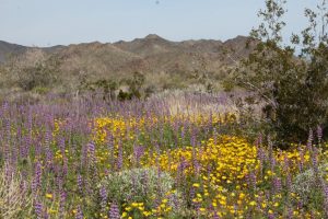
Wildflowers carpet the sandy soil along the Bajada trail. Poppies dance in the breeze, humming birds flit
among the brilliant red trumpet shaped flowers of the Chuparosa, and the buzz
of bees is everywhere. I could sit here
all day.
We find our way to the north side of the park where the
Joshua tree forest rules. Many are about
ready to bloom. The rolling terrain is
dotted with piles of huge boulders; eroded remnants of the most recent volcanic
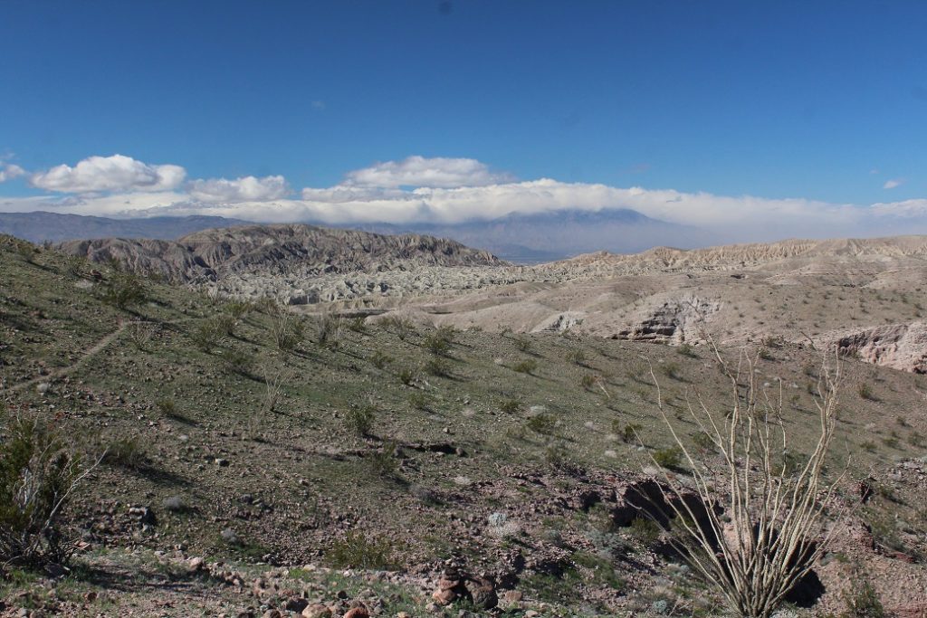
activity and the work of 1000s of years of wind and water. From Key View overlook snowcapped peaks rise
above the haze blown in from LA. It is not
as clear a day up here as we hoped but still worth the drive.
We go on to Barker Dam trail where a mile-long walk loops
past a lake in the desert. A natural
tank has been enlarged by dams built by cattle ranchers who have long ago moved
on. It is mid day and there are lots of
people around so not much wildlife. A
covey of 4 quail makes an appearance as do the regular desert birds. I am still looking for the big horn sheep. Even so, it is a beautiful cool oasis among
huge boulders.
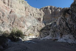
We creep our way back 4 miles of BLM managed wash-boarded dirt road to the trailhead for Ladder and Painted Canyon trails. The lot is pretty full so it doesn’t look like it will be a quiet commune with nature; but, we are here so on we go. Our plan is to hike the ladder trail first so we check out the maps and head out.
The trail begins in a wide wash bordered by steep high walls of clay-like soil. Sweeping swirls and trails of wax-like drips decorate the surfaces. Sand crunches underfoot. Within just a few hundred yards most of those sharing the trail turn off (more on that later) and we find ourselves alone as the wash narrows and begins to twist and turn. We soon discover that the entire area has been sculpted through years into beautifully colored narrow twisting canyons with steep walls between. That is where the ladders come in.
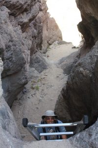
We spot the first set and head up…thankfully it is up the ladder; down ladder is much more nerve racking for me. We move on; twisting and turning and climbing ladders between canyons, admiring intricate shapes and splashes of color as we encounter wildflowers along the way. We are climbing boulders up narrow ravines now…seems like a lot tougher hike than described in blogs. We emerge atop a high ridge overlooking the great desert valley. It is beautiful!
But, the little blue dot on the trail app on Kent’s phone says we are way off trail…any trail! Oops. We relax and take in the view and lunch then decide to move on rather than backtrack. We noodle a bit then choose a somewhat worn path that seems about the right direction. This trail is terrible underfoot but is followable. After a mile or so we descend into a wash with lots of fresh footprints in the sand. It turns out to be Painted Canyon. Alright, we are back into charted territory and enjoy the beautiful stroll back toward the trail head. It was definitely not the path we intended but still a great walk. So, the turn-off that everyone else took just a couple hundred yards in, looks like we should have gone with the crowd. These trails are not simple loops and counterclockwise ended significantly different than clockwise must have. 6 ½ miles instead of 4 ½ but no scrapped knees or twisted ankles. We’d do it again. Who wouldn’t like trails with ladders?
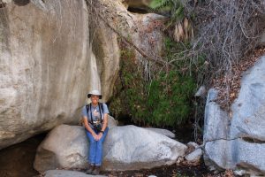
Well sort of. After a
fair amount of route finding and rock scrambling, we find a sheltered cliff
maybe 30 feet tall covered with dripping moss complete with ferns and a frog pond
at its base. About right for this arid
place. It is a peaceful, cool, shaded
spot.
That is what we found at the end of Hellhole Canyon trail in
Anza Borrego SP. It is a difficult last
mile or so and if you are not careful you might miss the falls once you get to
the “top”. The rock scramble back down
is a test for knees and hips too.
Humming birds, hawks, crows, and black throated sparrows entertained us
along the way but we didn’t see any big horn sheep.
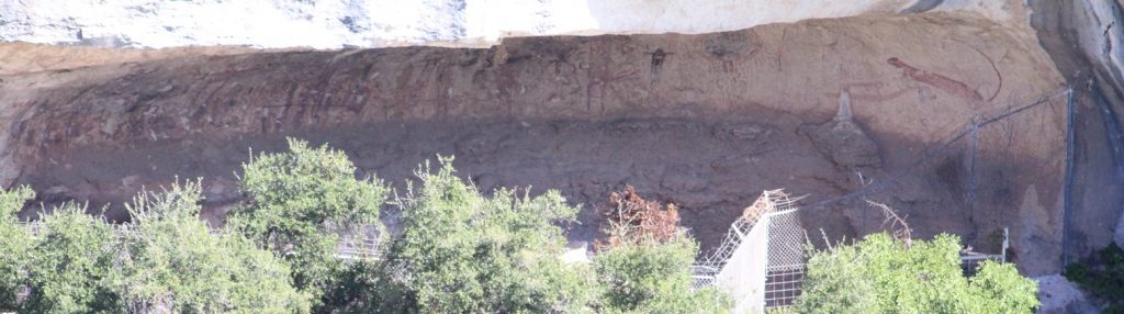
The main attraction here are the petroglyphs high on the canyon
wall, especially a 9-foot-long red panther.
One can view this art by private boat; put in the Pecos river (it is
shallow and rocky), come up the Rio Grande (against the current and nearly
constant winds), and turn into Seminole canyon…14 miles round trip; or you can
go by trail. Given the navigational
challenges we choose to hike. We wind
along on the edge at the top of the canyon with great views of the desert and
the rugged cut below us. The cool breeze
offsets the heat of the blazing sun to make for a wonderful walk. There has been a bit of rain and wild flowers
peek out from sheltered soil. Sparrows
of all types join Phoebes, Meadow Larks and Pyrrhuloxia darting shrub to shrub
against the desert wind. We reach the official
petroglyph overlook and are reminded that one sees only the tail of the panther
from here. We settled for that look last
time we were here but today we take an informal trail another couple hundred
feet along the canyon edge where we get a much better view of the cliff
art. We take in the view and relax in
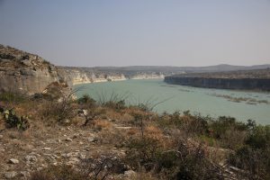
the quiet then head on around the bend following a cliff edge high above the
Rio Grande with magnificent views of the broad river and the matching cliffs on
the Mexico side.
Oh please, no wall here.
On an evening walk I encounter a jack rabbit. He looks like he would trip over those long boney legs and ears look too sizes too large. I have seen them run though and they are definitely built for speed.
Thorny Creek trail winds across heavily wooded ridges and ravines within Seneca State Forest. Mountain laurel and rhododendron blanket the creek banks as the water dances across rock and moss. We rock hop creek crossings as we scan the heavy brush for signs of wildlife. Nearly all sound is absorbed by the thick underbrush and leaf cushioned forest floor. We climb, descend then climb again as we move to the ridges above the creek. Water sounds are muffled now and our footfall tell the story of the terrain we cross. A dull thud upon cushiony soft moss, a swish through autumn leaves, the snap of dry twigs, and the crunch of fallen acorns. Sometimes winded, sometimes lost in the serenity that surrounds us; it is a wonderful journey. Take a walk among the trees.
Let’s hike. A lovely sounding Riverside trail just below the dam turns out to be a muddy mosquito rich walk through brush that is mud stained over waist high from the September floodwaters. There aren’t even many birds to watch.
Ok, lets try the Terrace Mountain Trail up along the east side of the lake. Just turn onto Corbin Road right here. 500 feet later we encounter the “Road Closed Ahead” sign. It looks like we are not meant to hike today. We swing by Dairy Queen for cones (mine is butterscotch dipped) and head back to camp.
The sun is bright and hot but there is a bit of breeze so it ought to be cool enough to kayak. We gear up and head out along our little bay with the wind to our backs. It is cool and peaceful. The local cormorants and great blue watch intently then move just out of our path to let us pass. We easy paddle back to camp.
It is a clear night and we see three shooting stars as we soak in the peace and quiet. The screech owl we have been hearing made a low altitude flyby as we sat star gazing.
Trails here are about mountain vistas. They are also about steep rocky climbs and today, the Vista trail is about mud. The first two miles are basically uphill (1300 ft) through cool, rocky, wooded terrain. We thought we were moving at pretty good pace until we heard footfalls behind us and “coming through”. Hmm. We trekked on. Another approaches from behind. Then another. We are overtaken by trail runners. They speed fearlessly across the loose stone and tree roots thrusting themselves uphill and later careening down. We came to learn later that over 100 runners were out there on a half marathon trail run. I will stick to walking thank you.
It is a splendid view from the top so we chill a bit then head on down. Yucky surprise, this half of the loop passes through a really boggy section (on a mountainside no less) and we slog our way through the mud. Lucky for us, we wore our boots. Lucky for them, the runners were routed around the worst of it.
We close out the day with a stop at the Eagles Mere scarecrow festival. Five local wineries were represented, the local music wasn’t bad, and I bought a bit of pepper cheese from a local producer. We stayed long enough to grab a sandwich from the local mercantile but soon make our way home.
Evergreen trail winds through a mature forest under towering hemlock and white pine some are over 500 years old. A grove like this is a rare find in this heavily lumbered part of the country. Bonus, the trail starts at a waterfall.
Our second venture today is on the Grand View Trail, We should find a grand view/great vista, right? Not so much. It was a nice walk through the woods and we meander across a lovely woodland glade but trees obscure anything remotely panoramic. Upon our return I checked in with the rangers to see if we’d missed a turn or something. Nope. There is no grand view. Not since the forestry department quit maintaining the fire tower! Ok then.
The afternoon sun is warm so we hang out on the lakeshore. It is pretty quiet until eagles show up and bicker over who gets the best roosting spot. Once things quiet down again we head back to camp to grill some burgers. We still have a couple of those delicious farmers market tomatoes and they are fantastic on a grilled burger.
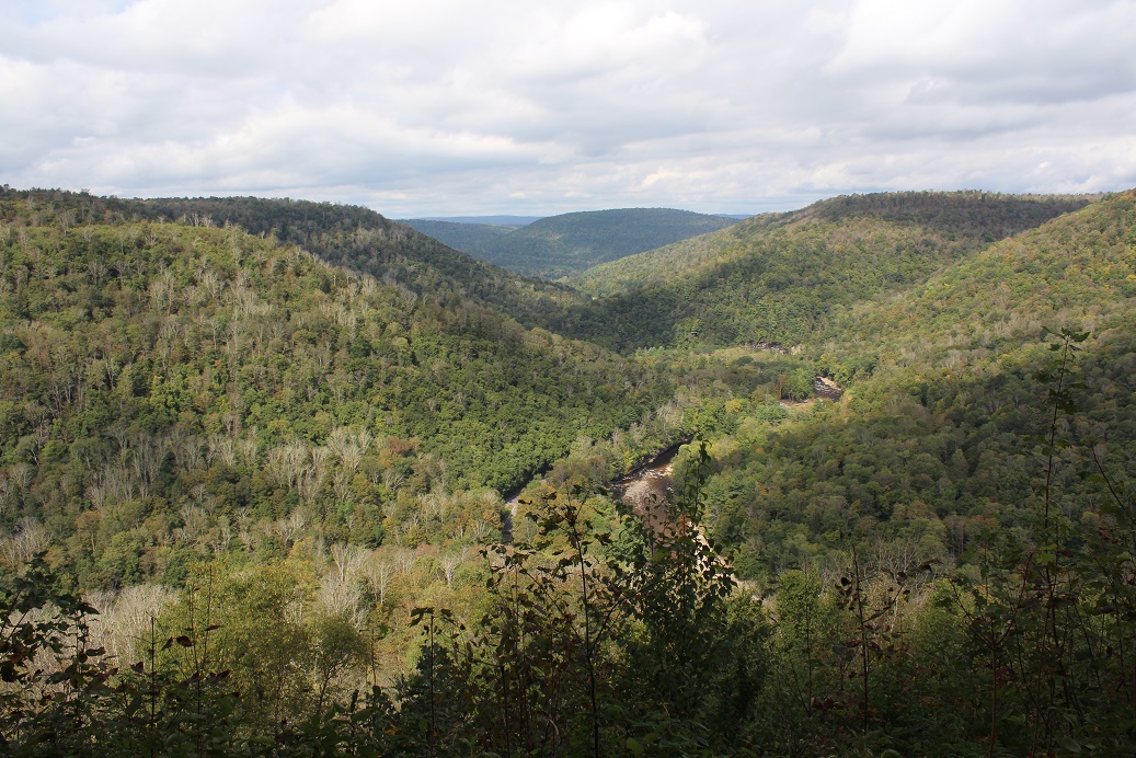
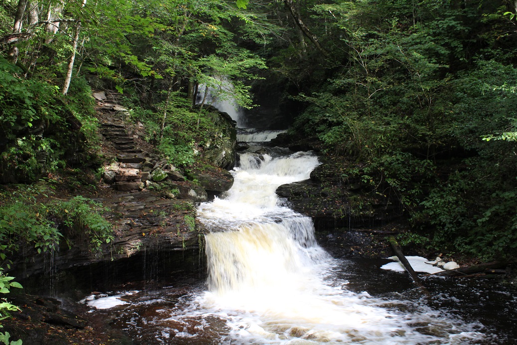
The main trails in Ricketts Glen State Park form a V shape as they track two wild streams cascading down intersecting ravines to merge at “Waters Meet”. It is a great walk.
From the trail head we meander through dense woods among scattered moss and lichen covered stone. It is a serene quiet path. Then we begin our decent into Ganoga Glen on a trail that follows the waters edge. At this water level, still pools are very rare as the coffee brown stream leaps down the rock-strewn creek bed. Side creeks add to the flow all along the way. We pass10 named falls including 94ft Ganoga Falls. Breaks in the clouds send splashes of light dancing across the surface. The trail is wet but not muddy and there are well placed stone steps. The trip down into the ravine is great.
We spy a bridge through the trees that signals we are nearing “Waters Meet” and the beginning of our climb back out. The view at the confluence is fantastic with falls on both streams and wild cascades downstream from here. We chill for a bit then head on up the Glen Leigh trail. It tracks the stream even more closely as we crisscross as many as 8 foot bridges and walk right up to edges of falls. I’m pretty sure that this was the best wild waterfall trail we have walked. Others have had more grand arched bridges and walkways but here I really feel we are part of the landscape. Don’t miss it if you are close.
Our final leg is the Highland trail where we find the stone outcropping that is responsible for this all. It obstructs streamflow and divides it to create these separate streams and allow for the spectacular merging. There is a cool stone bridge along this stretch too.
That’s all the hiking for today. We find a spot in the sun (it is still 57F) on the lakeshore for lunch then check out the big beach on Lake Jean. Clouds thicken and a cool breeze runs us indoors. Kent spends a bit of the quiet afternoon mounting medallions I have accumulated, a total of 34 new ones.
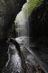
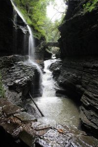
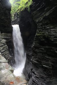
Skies are overcast but rain is supposed to hold off until late afternoon/evening. Today we are off to Watkins Glen. This gorge is the area’s signature hike so we have to do it even though we have both walked it a time or two before. The hikes are different every time. We start off at the south entrance and drop down into the gorge right at a spiral staircase that leads the trail behind a wall of water. Very cool. We checked that out then continued up through the gorge dodging lots of dripping ledges, oohing and awing at the sights around every turn. I think the gorge at Treman is a bit more dramatic but this one is fantastic too. If water falls are you thing, this is a great place to check out.
While we are in town, we check out the Seneca Lake Watkins Glen Marina. Sailboats crisscross the water in front of us but don’t go far down lake. Winds are picking up and expected to be 40 mph as the cool front bringing rain moves in. It is a lovely place to just hang out and we had our picnic lunch. We cruise by a couple roadside waterfalls and make our way back to camp.