Sunday Drive

Today’s drive was a big loop east and north of camp. It started out with a lurching, near tire squealing slam of the brakes when a buck just burst into the roadway.  We took a deep breath and continued on our way.  Dry, low rolling plains gave way to endless grain fields waving mesmerizingly in the morning breeze.  North just 50 miles or so put us in thickly forested mountains much like the Appalachians.  It was an amazing contrast to the scablands along the lake shore.  Columbia Princess Comp_4317Our route took us across Lake Roosevelt on the Columbian Princess, another local ferry.  She carries about a dozen cars.  We got a close up view of how it all works.  Pretty fun.

Serious history buffs

A Quartermaster’s stable, brickFort Spokane Comp_4313 Guard house/cells and powder house are all that remain of the structures that comprised Ft. Spokane in the 1890s.  A trail meanders across the grounds with signs interpreting old foundation sites and land use.  It is interesting but a bit unexciting.  Ft Spokane ReenactorsComp_4310It all comes to life when we meet two fellows from the 2nd Cavalry (re-enactors of course) who share stories of the time.  The tiny camp is chocked full of vintage firearms, tack, and camp gear along with replicas painstakingly researched and created by hand.  We linger to hear it all until the next group shows up and we have to move on.  At the visitor center, the ranger is equally enthusiastic and filled with stories about the fort and the area geology.


Why a fort here? Geology.  The great ice age floods (sound familiar?) created this channeled scabland but the region along the west side of the Columbia River was protected from that powerful erosion.  Top soil and all that grew here were spared.  The result, great crop land.  It was designated an Indian Reservation making it off limits to white settlers.  Settlers squatted and Indians protested.  Ft Spokane was built to house troops to protect the Indians and their rights from the settlers.  Sort of a turn around from most interactions.


Ironic – and pretty sad

Once troops were no longer needed and the fort abandoned it was given to the Bureau of Indian Affairs who promptly made it an Indian boarding school. They forcibly removed young Indian kids from their families to be “educated” and stripped of their cultural ties.  Assimilated.  What a reversal in roles for this piece of property.

Inspired by the National Parks

Quilts. The touring collection is here in Coulee Dam for the Holiday celebration.  Some depict the iconic image for the park; like wolves for Yellowstone.  Some express more the feeling of the park or a sense of the terrain they protect.  Most are small wall hanging size.  I would be happy to have any of them in my house.

Cruise, float, and snooze

It is cool this morning. I wrap the beach blanket around me as we slow troll along the shore.  Wildlife is a bit scarce but we see eagles, osprey, deer and a few mergansers.  Cliffs alternate with green encircled bays.  We stop and just float.  The quiet is amazing.


We drop anchor in a protected bay to people watch. A ferry carries State Rte 21 traffic across the lake 12 or so cars at a time.  Power boats fly across the wide lake with all manner of stuff in tow.  House boats head out in search of sand bars and bays to anchor for a spell.


Last stop for today, a quiet sandy beach. We take a dip-the sun has gotten very hot – then take a nap.  This is relaxing.

Checking out where they pump all this water to.

The destination for the huge dam pumps is Grand Coulee (more geology – an enormously wide flat-bottomed channel blasted through ancient basalt during the great ice age floods) to create Banks Lake reservoir that starts just above the dam.  We head for Steamboat Rock State ParkSteamboat Rock Comp_4277 just a few miles down the Banks Lake shore.  A mammoth basalt mesa has been partially submerged and does indeed remind one of a steamboat.  It is 80F by 10AM so we walk to the base of the cliff but opt not to clamber on up.  Local wildlife is feeling the heat too.  A doe is quietly munching in the shade of a scrub tree.  She hardly seems to notice us. Fawn Comp_4270 On our return I spot her fawn.  The little fellow is safely tucked away in the cool shade of a huge boulder.  He watches but doesn’t move a muscle.

One last amazing rock formation

We reach the end of Grand Coulee and Banks Lake.  Just beyond is Dry Falls.  Not so interesting you might say. DryFallsComp_4273 You’d be surprised. The cliff receded over 25 miles as violent flood waters blasted away layers of basalt.  The water found another path and the flow diverted.  A wall of rock 400 feet high and 3 ½ miles across stands now, dry, as a fantastic reminder of the power of natural events.  Much cooler than you likely suspect.

A day on the water

It is a beautiful cool morning with a forecast high of 97. We decide on an early start.  The Holiday crowds are beginning to arrive but the ramp is not too hectic yet.  We launch without incident and set out exploring.  Coulee Dam is impressive from the water side too. Grand Coulee Comp_4262 We alternate swimming, running about and sitting on a shady beach.  Overall we managed to enjoy a day on the water even though it did get very hot again.  Tomorrow might be a bit cooler.  We shall see.

Dam day

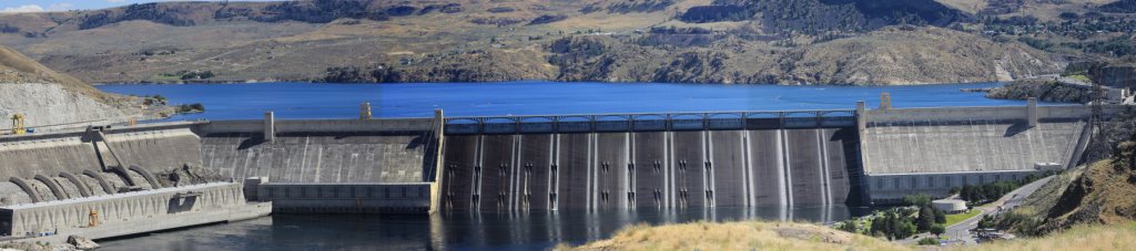
I am certain that I have heard more “Dam” jokes today than any other time in my life. We are at Grand Coulee Dam and tour guides, drivers, visitor center staff, even video narrators all get in on it.

GrandCouleeDam PanaramaComp

Besides all the bad jokes; there is a lot of concrete, holding back a lot of water, running lots of huge generators, and running mammoth pumps. Seems this dam, though huge, is not high enough to allow gravity feed irrigation to the rest of the state.  To get the level high enough they would have flooded far into to Canada, a nono at the time.  So, they pump water out of Roosevelt Lake up another 280 feet or so into an irrigation reservoir (Banks Lake) then it travels though canals and ditches to 100,000’s of acres of crop land.  We saw the pump room on our tour.  It’s all pretty remarkable.

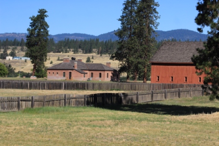
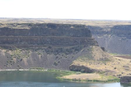
Of course there is the downside. This dam single handedly drowned out over 135 miles of wild Columbia river, its habitat and natural wildlife.  It is another place that would have been amazing to see untamed.

Not at all what I expected.

We found good seats on the river side bleachers with a great view of the face of the dam. An imposing voice boomed, “take your seats please, the laser light show will begin in just a few minutes”.  In the twilight, the surface of the dam begins to brighten.  The giant spillway rocker gates are cracked open to release just enough water to create a very cool white “screen” across the entire spillway surface for the light show.  Ok, what’s next?  A beaver.  Yep.
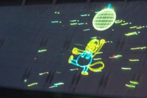
Disco Ball Beaver

Disco Ball Beaver

He is sort of their mascot.  “After all, who knows more about dams than a beaver?”  This laser light image pops out of manhole covers.  Dances.  Carries signs and narrates a fun series of Coulee Tunes cartoons.  It is sort of like the old pre-movie cartoons at the theatre.

Then there is the main feature. The Many Voices of the Columbia.  It describes birth of this geology, use of the lands by first nation’s peoples, use by white explorers and settlers and finally the building of the dam.  Definitely a propaganda film  but well done and fun to watch.
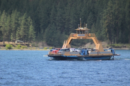
 

Lake Roosevelt NRA

Spring Canyon Campground in Lake Roosevelt NRA.  We can see the top of Grand Coulee Dam and a broad expanse of Lake Roosevelt.  Much of the shoreline resembles that of Lake Mead, sage brush and desert-like.  The biggest difference is that this lake level doesn’t vary much so the banks are a bit more inviting with some sand beaches and trees.  Still in-the-water is the real recreation on this part of the lake.  There is a beautiful swimming area with beach and sand all with a smattering of shade trees.

It is a great find for the holiday weekend.

There are many quail in and around camp. I hear them often and have seen groups of adults and even a family that includes 8 or 9 cute little ones.

North Cascades Highway

We pass through “The American Alps”.North Cascades Comp_4234 Steep, stark peaks jut into the clear blue sky.  Dark rock is accented with brilliant streaks as sun glints off snow and melt streams.  Lush green meadows drape like shawls across the mountains shoulders.

The motorhome worked pretty hard during this 220 miles in 6 hours (so did the driver). But it’s worth it.


That’s weird. We dropped over one mountain and the temperature jumped from 70 to 90.  Something must be wrong with the thermometer!  But, no; it is really that hot here in the Columbia Basin and its supposed to stay that way for at least 3 or 4 days.

It’s a bit hard on people but seems to work well for their agriculture. Take that killer heat.  Add lots of water (collected behind the Grand Coulee Dam) and apply it to some rich ancient volcanic soil and you can grow anything.  We stop to sample product of that successful combination, Rainer Cherries and tree ripe peaches.  YUM