A lodge and hydro plant have encroached pretty heavily in this rugged ravine but the 250+ft drop is still impressive.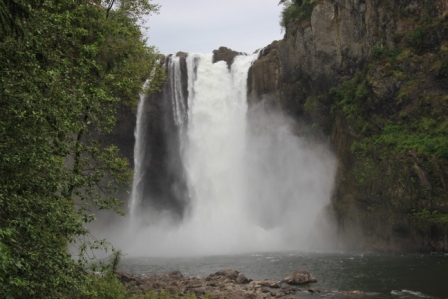
The Falls
Reply

A lodge and hydro plant have encroached pretty heavily in this rugged ravine but the 250+ft drop is still impressive.
A fifty mile stretch of the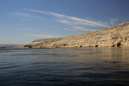 Columbia River has been protected from development, hydro dams and agriculture first by its inclusion in the Dept of Energy Hanford Project and now as a national Monument. It is a little difficult to get to usable launch points but it was worth the trouble.
Spring flow rate creates significant current; over 6 mph is some places and full of swirls and whirlpools. It is an impressive waterway both for the flow and for terrain it slices through. We powered upstream then enjoyed the amazing quietness as we floated back down. The river bank oasis in this otherwise arid place attracts deer and coyotes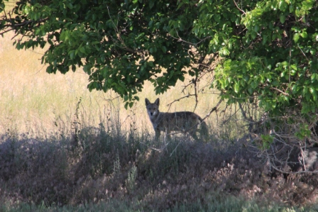 plus a nice selection of waterfowl.
It is not exactly a wild river since flow is governed by the Vernita Dam just upstream. There is still a fare amount of DOE infrastructure visible above the 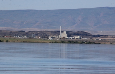 Hanford side banks. Still, it was a beautiful and peaceful (ironically) trip.
Who knew that states named “state waterfalls”? 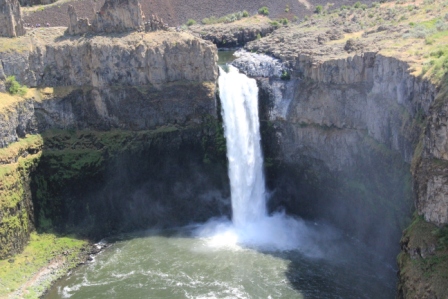 Here in Washington it is the 198 foot Palouse Falls. It is Spring and the river is flowing full. It roars as it drops into the cliff-circled basin. Don’t miss the cascades just upstream.
 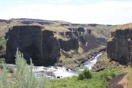 They are classic Washington…without the surrounding forest. Check it out, Palouse Falls State Park.
Country Mercantile is not exactly a roadside farmers’ market or field stand. Shelves are lined with all manner of specialty foods along with their own bread, flavored butters, hand dipped gourmet chocolates and nuts, plus in-store churned ice cream. We sampled our way through the store (mostly I did) trying chocolates, jams and even asperagus ice cream. Oh yeah, they do have some local produce. We picked up some just picked sweet corn. I can’t wait to try it!
Pasco Farmers Market
The corner of 4th and Columbia is home to a couple dozen vender booths. There are some very creative crafty booths but many are offering local fruit and vegetables. Cherries are ready. We brought home delicious Chelan and Ranier. A big bag of spinach and some snow peas rounded out our “good for you” buys; add to that a sampling of local baked goods that were just too good to pass up. I envied those with a place to display them as we walked past a booth filled with bright spring colored floral bouquets.
Wine is big business here in Washington and each region vies for attention. So besides being very cool that geologists can infer a fantastic, complex sequence of events to explain why this place looks like it does; the resulting landscape is claimed to be perfect for red wine grapes. Fortuitous side benefit I would say! I have picked up bottles of the signature reds (Cabernet Sauvignon, Syrah, and Merlot) from this region. I will keep you posted as they are uncorked.
From atop my exquisitely carved stead I snag a ring each revolution from the mouth of a beautifully carved salmon. Red, yellow, white, pink and finally the brass ring. Two rides for me today, hooray! (felt a bit like a kid just then).
Kennewick, WA is home for a restored carousel that first thrilled riders in St Joseph Michigan from 1910 to 1970. When it fell into disrepair the full set of horses was rescued by a collector who kept them safe and all together until the Kennewick community came together to bring it back to life.
Charles Carmel carved the original horses.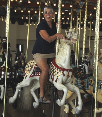 His “tell” was lolling tongues. Check out my ride. He’s a prefect example.
The works are new, built at the Carousel Works in Ohio that we checked out a year or so ago.
Can geologists really know all this just by looking across this landscape? For thousands of years, layer after layer of slow moving lava spread out over great plains. As it cooled it contracted and fractured creating vast expanses of columnar basalt. Icefields expanded covering the region grinding channels and blocking rivers. Colossal Lake Missoula formed behind ice dams. Ice dams broke and flood waters raged. Ice advanced. Lakes refilled. Ice dams broke and flood waters raged.
Each time, Wallula Gap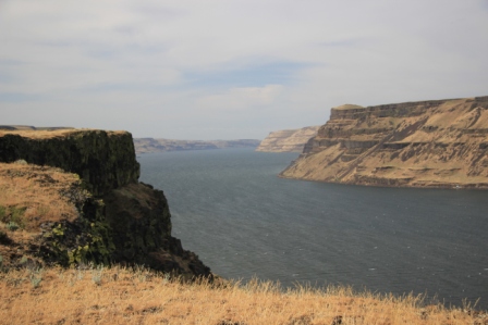 was the restriction that held back a wall of water some 1250ft high and like a nozzle it generated a powerful stream that eroded enormous basins and flow streams in the basalt fields.
The Columbia River flows through that gap now. We hiked to the top of its craggy cliffs for a pretty fantastic view of this handiwork.
Reactor B is a graphite block, single pass
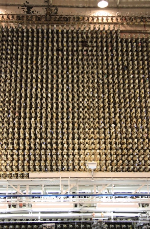
Reactor B Fuel tubes
reactor that was built for the sole purpose of producing weapon grade plutonium. Looking up at the 2000+ fuel tubes making up the reactor face rising high above us evokes some hugely conflicting reactions. What an engineering accomplishment. What a horrific and brutal goal.
Tour guides work to explain in layman’s terms the processes that took place here and to put the project in context as “the way to bring World War II to an end”. The story starts with the condemnation of land and eviction of settlers and Native Americans to create the 600 square miles Hanford Complex. 50,000+ workers descended on that land during the construction phase. Plutonium from Hanford was dropped on Nagasaki. Stockpiles grew. World tensions eased. One by one, reactors were shut down. Today, cleanup efforts continue to one day return this land to another use.
We made a quick stop at Klamath Basin Wildlife Preserve in southern Oregon. They get some priority for water since they provide critical habitat for threatened species but the drought has hit them hard too. Lakes are a fraction of their normal size and wetlands look more like pasture fields. Still, it looks like an oasis to local wildlife and they tell us they will be over run as the fall migration makes it through here in another few weeks.
Deep (1943ft). Cold. Pure (only rain and snowmelt from within the crater). Huge (5 miles across). Spectacular. Unfathomable (5 trillion gallons of water and 34 million of that is exchanged each year with seepage and evaporation balanced by rain and snowfall) Awesome (some really weird geological formations). There are many ways to describe the better known volcanic park, Crater Lake, and they are all memorable but the thing most impressive is the Blue of the water.
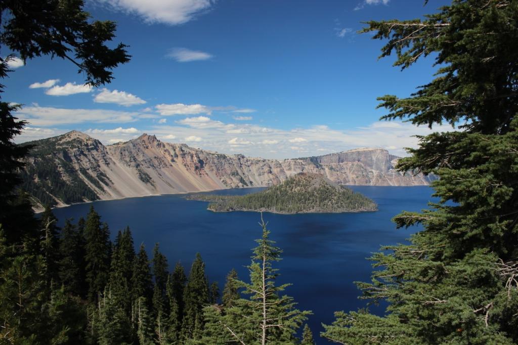
Crater Lake NP
Trails to fire towers on the peaks of neighboring volcanoes gave us panoramic views of the lake and its place in these fantastic surroundings. This was a 12,000 ft mountain. Now it’s a lake. Some pretty cataclysmic stuff happened here. Stops along the drive give great views of the two islands, phantom ship (a cool ship-like rock formation) and wizard island (a cinder cone with a still visible crater).
It is dry and high forest fire risk. There are actually two fires burning within the National Park; a very small fire inside the caldera and another a few miles north. California is having fires too. We are amid thousands of acres of national forest with lots of beetle kill stands and very low rainfall. Fire fighters have their hands full.
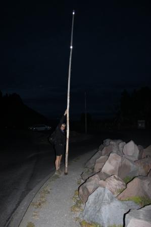
These are serious snow poles!