
The trail follows the![]() slope of Clear Creek up through a heavily forested ravine. The sound of water tumbling across rocks is our near-constant companion. My kind of trail! We start with a creek crossing then move into heavy aspen and willow so thick and untamed that it is encroaching on the trail. We don’t have any trouble following the path but the vegetation is wet and we are now too. We break out the raincoats when a light rain moves in but continue to move up along the creek. The rain stops as quickly as it began. Aspens have thinned and we are surrounded by pines now. Scat and animal tracks confirm that wildlife appreciates this area too. It looks like we’re moving through the home of moose, elk, deer, bear, and probably fox. We come upon scattered forest clearings where tall grasses are dotted with a rainbow of wildflower colors. Woodland birds dart about rarely stopping long enough to even attempt identifying them.
slope of Clear Creek up through a heavily forested ravine. The sound of water tumbling across rocks is our near-constant companion. My kind of trail! We start with a creek crossing then move into heavy aspen and willow so thick and untamed that it is encroaching on the trail. We don’t have any trouble following the path but the vegetation is wet and we are now too. We break out the raincoats when a light rain moves in but continue to move up along the creek. The rain stops as quickly as it began. Aspens have thinned and we are surrounded by pines now. Scat and animal tracks confirm that wildlife appreciates this area too. It looks like we’re moving through the home of moose, elk, deer, bear, and probably fox. We come upon scattered forest clearings where tall grasses are dotted with a rainbow of wildflower colors. Woodland birds dart about rarely stopping long enough to even attempt identifying them. 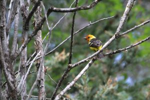 Kent does get a good look at this Western Tanager. It is getting muddy and badly eroded making it hard on the ankles. We turn back after 2 ¾ miles. It has been a good morning.
Thank you to the gentleman at the Montpelier District Ranger Station. He recommended this hike as a foot trail only, quiet and through an area frequented by wildlife.
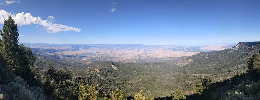 A mostly well-maintained gravel road crosses through mixed forest and open meadows. Wildflowers are spectacular with predominant colors changing area by area based on moisture, shade, wind and I don’t know what else. Wild life viewing continues to be disappointing. We see cattle, they have grazed livestock here for decades, and very tame chipmunks at the observation point. Below us from the point we look out across a wide arid valley sided by basalt capped cliffs and eroded slopes painted muted rust and tan. Smooth mounds are scattered on the valley floor, oddly placed and shaped. All this the product of eons of erosion as the Gunnison and Colorado Rivers come together here. Now, man has made our own mark as the city of Grand Junction and local agriculture with its associated irrigation have created a sprawling green-grey oasis. I wonder what it looked like when only the ribbons of green of the two rivers traced along the valley floor?
 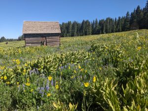 Heading back from the point we hike the Raber Cow Cabins trail thigh high through the flowering meadows and among cabins dating from early ranching days. I could look at this view every morning.
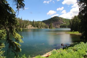 we walk the banks of Mesa Lake. It is lovely, mostly shaded and cool. We had been warned about mosquitoes and we find them on this trail. Even with plenty of repellant they find us if we dally too long or disturb the brush. Fishing is a big thing up here and we see quite a few rainbow trout in the clear lake.
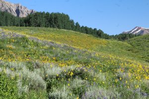 Snodgrass Mountain, head out pretty early for the drive to put us on the trail by 8:30 or so. The area is amazing with entire hillsides painted mostly shades of yellow but dotted with purple, blue, red, white and orange. Snow capped peaks ring the valley along with the namesake crested butte. Wow! We hike about 4 miles through meadows and treed terrain. What a great time of year to be here.
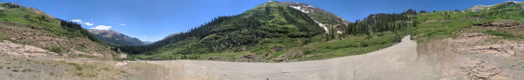 The pictures don’t do it justice. Two marmots cavort on the rock pile providing lunchtime entertainment. We won’t be finishing the loop drive. We meet a Crested Butte bound driver who reports that some earlier driver overestimated his skills and is stuck in remaining snow pack. They have blocked the road and no one is getting through. So, home we go.
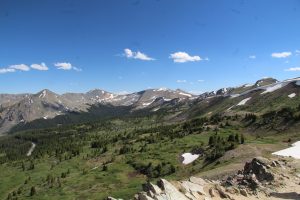 There are switchbacks and hairpin curves and quite a bit of traffic but the drive is lovely and pretty easy. We are in the Sawatch Range and the pass is at 12,119 ft elevation, the highest paved crossing of the continental divide in the US. We hike up another couple hundred feet to an amazing view on a trail that winds through a wildflower covered alpine meadow. It is beautiful in every direction. Trails go on from here but we hang for a bit then head back down then to camp for a quiet evening. The host says there was a bear in camp last week. I’ll believe it when I see it!
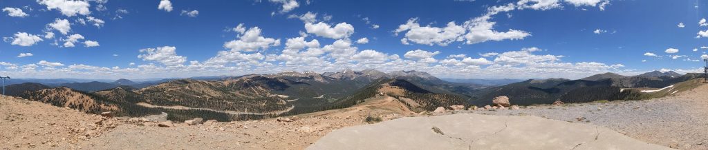 Then, we are on to Monarch pass via US50 to check out the view from 11,312 feet and with a gondola ride up to the top, 12,000ft. The gondola ride is a bit exciting as the cars bounce in the wind. It is clear and we see Pikes Peak and The San Juan Mountains, about 80 miles. We hang and enjoy the views for a bit then are on our way. The rest of the day is filled with some shopping to restock and prep to move tomorrow. On to Crested Butte and a quiet National Forest Campground, Lottis Creek.
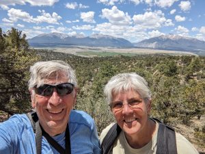 , a walk through wild space with hopes of seeing deer maybe elk and maybe even bear. It is rugged and beautiful as we move along first an old two track road then dry stream beds. Granite monoliths rise high above us with pinon pine and juniper in the valleys between them. We do notice there is not much shade and that the trail is often soft sand underfoot. Neither is what we were expecting. We manage to get off trail following the path of what must have been a trail ride. We wind up trailblazing up and down three ridges and their associated troughs. It’s getting hot and we are a bit tired and exasperated at the difficulty finding the trail. One more climb and tada, we are back on the trail and heading for high ground where we find fantastic long mountain views out over the valley to surrounding 14000s. We are feeling the heat and elevation so cut the hike a bit short and head back. So far one cottontail and a couple chipmunks. Good thing the views were nice.
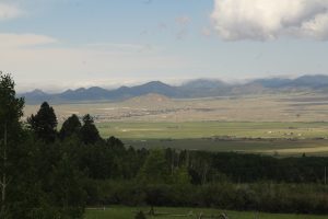 Check out this view from our site.
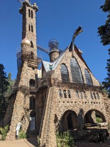 amazing roadside find, a one-man project, Bishop Castle. It is three stories of stone and iron with flying walkways, stained glass, seemingly endless spiral staircases and a dragon head. We climb and weave our way through towers and inner rooms. What fun. Kent makes his way high into the spherical topworks of the tower. You could climb around for hours searching for hidden chambers and stairways in this structure.
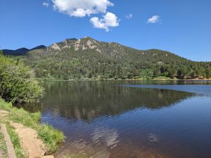 We stretch our legs on the circle trail around Lake Isabell. There is lots of fishing happening but according to the folks we talked to not much catching. Rainbow trout are the target catch. We cruise through the NF campgrounds and picnic areas all along a creek and nestled in the edges of the thickly wooded valley. There are a few sites that could accommodate us….someday maybe.
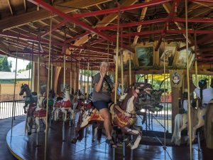 It is #72, county fair style, built in 1911 as the 72nd by Parker Amusement Abilene KS. The current complement of carved horses isn’t all the originals but they all date to the early 1900s. I am doubly excited because they even have a working band organ. Sadly, they only play it evenings so I miss out on my afternoon ride. Bummers, watching the instruments and hearing that distinct sound is a big part of the carousel experience. Still, it was a fun ride and only $0.50.