
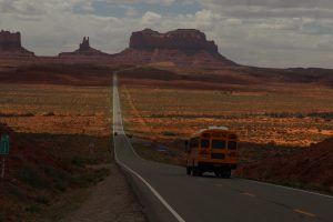
We spy the Monument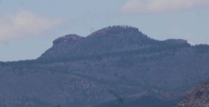 namesake, Bears Ears Buttes. We are out along Colorado 95 checking out Puebloan ruins and get a pretty good outline on the horizon.
Stop one is Edge of Cedars State Park Museum just outside of the Monument in Blanding. They house a large collection of Ancestral Puebloan pottery and artifacts wonderfully displayed and curated. 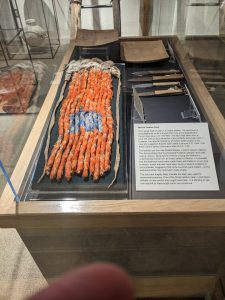
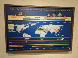
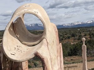 Stuff I didn’t know or never saw: stone arrowheads on a yucca strand to be carried like an ammo cartridge, a chart comparing the eras of world civilizations – the Anasazi span is remarkable, a sculpture demonstrating the use of shadow and sun-light beams for telling seasons and “time”. We have made our way through a number of museums housing similar artifacts. It is fantastic to come across something new. There is a partially excavated and restored Pueblo Village on the ground. We explore including checking out the inside of the Kiva. Edge of Cedars is definitely worth a stop.
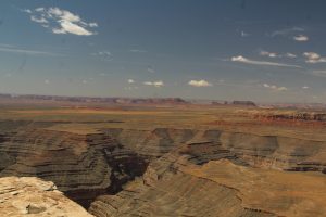
Bears Ears NM claims over 100,000 cataloged archeological sites scattered on cliff edges, atop mesas, in washes, and in streambeds. Many have not been explored or fully documented. We check out a few of the more accessible ones. Alcove dwellings great and small, some amazingly intact others eroded and looted. Remnants of cliff-top towers that stood guard or maybe provided elevation to communicate over distance. Circular Kivas, the space for rituals or the mundane or probably both. There is still a lot to learn about all these ancient civilizations and those doing the studying are trying desperately to keep looters and even casual hikers from spoiling the finds. They have a whole set of rules here that parallels the hiker’s mantra, “Leave no trace” but goes on to admonish all to follow unique site protective guidelines. This place definitely deserves at a minimum, the protections afforded by National Monument status.
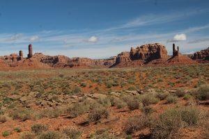
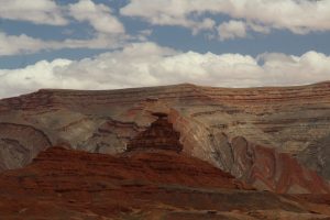
 . We start with Valley of the Gods, a smaller scale Monument Valley. 17 miles of narrow gravel road wind through a field of redrock formations. Shadows and colors are beautiful in the morning light.
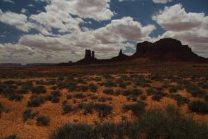
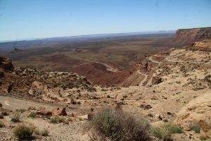
 Utah starts off through a wide valley of rolling desert scrub. By mid-way through the trip, red sandstone formations begin to appear on the landscape. As we move on, gigantic monoliths and delicate spires become more and more common. Soon we find ourselves in the middle of Monument Valley. It is awesome. We have to stop at Forest Gump Point for a quick selfie of course then its on to Hat Rock near the town of Mexican Hat and finally our new home. We are at Cottonwood RV in Bluff for next few days.
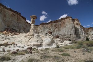
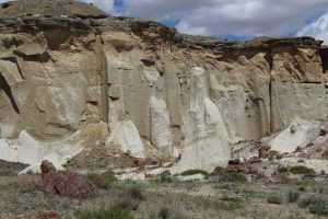
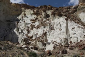 bed of Wahweap Creek is a collection of cool looking, odd shaped, gravity defying towers. Dakota Sandstone caps sit atop towers of Entrada Sandstone that the powers of wind and water have carved free from surrounding cliffs. Around the spires are mounds that resemble melted candles and recesses filled with intricate shapes and curtains created as waters recede and evaporate redepositing rock. At our feet in the flow channels of the creek-bed, the last vestiges of floodwaters have carved what looks like miniature versions of the canyon features all around us.
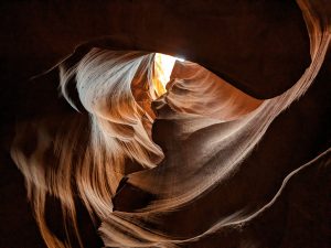
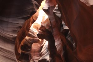 It has been on Kent’s bucket list a few years now to see Antelope Canyon. We have seen some spectacular pictures and want to see the real thing. The slot canyon is on Navajo land and access is by guided tour only, not our typical way to see great works of nature. Today is the day. Step one, load up onto bench seats in the back of a pickup and bounce along a dry wash for 15 minutes or soIt is early so still cool and we are a smallish group, 10 total, rather than the 14 in many of the trucks. Not a bad ride, then here we are. There are rows of tour trucks and vans. How on earth do they manage this many people through this little canyon? Our guide, Craig gathers us together and
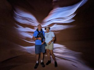 chats ‘til our turn to enter. From the outside the canyon is really not very impressive, just a dark, narrow-topped opening in a dull brown rock face. Just a couple feet in and we are surrounded by multicolored, swirling patterns in smooth stone. I took a ton of pictures. None do it justice. With each step the view changes with more or less light and wider or narrower pathways. We didn’t get the noon time tour that is known for its spectacular sunlight beam down through the chamber but our guide did great pointing out cool views and perspectives and taking pics for us all. Go if you can. It is a unique and wonderous experience. They really handled the multitudes very well.
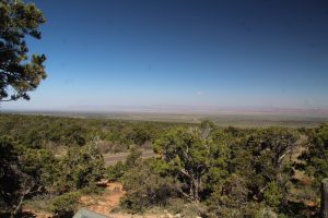 Vermillion Cliffs are striking but between the viewing distance and reduced visibility we see no condors today. At the intersection with the route to Grand Canyon north rim we find Jacob Lake Inn. It is famous for its homemade cookies. Had to try them of course; oatmeal raisin, snickerdoodle, and chocolate chip. All delicious but the snickerdoodles are my favorite. The parking lots at Lees Ferry won’t accommodate the motorhome towing so we have to skip it this trip.
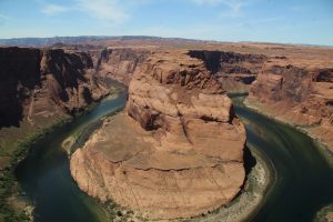 We cross the new Navajo bridge with its great view of the deep Colorado canyon then on to our last stop, Horseshoe Bend. From a bluff high above we can see a tight turn of the Colorado as it winds its way between towering cliffs. It is beautiful and awesome.
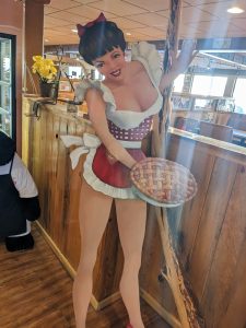 family restaurant at the Thunderbird Lodge. There is a perfectly understandable explanation, the original sign touting the proprietress’s baking skills was too small, “Home” did not fit! ‘Ho’ was an advertising success ultimately joined by a buxom beauty on their next sign. Whatever brings ‘em in I suppose. We had dinner and naturally had to sample the pies. We sampled Thunderberry (mixed raspberry and blueberry) and apple with buttered rum sauce. Delicious.
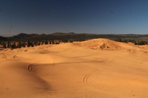 We get an early start knowing that sand dune hikes can be quite a challenge in mid-day sun.
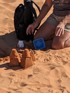 Sand castle building. I had a couple sand forms in the backpack and it worked out every well. Wish you were here to build with me again, Willa.
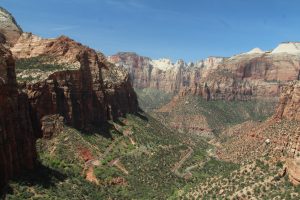 bird’s-eye-view of the switchbacks into lower Zion Canyon. As promised, the views are amazing. The trail is kind of busy and has several narrow one-way sections where it is cut into the cliffs. There is even a catwalk section and lots of rock steps, even and not so even. It is a little tougher walk than most “overlook” stops but well worth it.
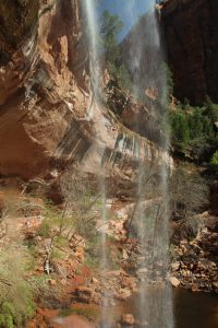
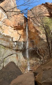 canyon cascade from cliffs high above the canyon floor. Airy, windblown falls pool on rock benches along the rock walls creating cool oases for wildlife and hiker. Today we check out the three emerald pools across from Zion Lodge. There are lots of steps and some steep ramp sections but this is a cake walk of a hike compared to West rim out of the canyon. We see up close the huge impact of water on this whole ecosystem, enjoy great canyon views, and even find a bench to sit and watch some climbers.