Lake Mojave

On the water

Mornings have been coolish and the sky a brilliant blue making it perfect boating weather, as long as we remember the sun screen.   We have been out two mornings so far.  The big horn sheep have not shown themselves yet and fishing has not been impressive, just two small bluegill between us. Looks like we might need to try different bait/lures and maybe get out a bit earlier.  We’ll see.

Out on the trails

Canyon trail.

It is a short walk but pretty great from a wildlife standpoint.  First, we actually stopped in the middle of the dirt access road to watch this huge spider, tarantula I’m pretty sure, cross the road.


On the trail, we 
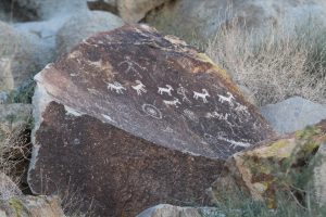
check out great pictographs near the canyon entrance then boulder climb back the canyon to explore.


Moseying along in the rock shadows we spot a desert tortoise.  It is one of 
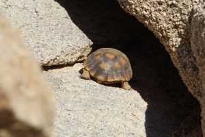
only two or three of these threatened fellows we have ever seen in the wild.  Very cool.


Fisherman’s Trail

I enjoy trails that are walk-out right from camp without having to drive anywhere.  This trail departs from behind the boat maintenance area (kinda weird) and follows the lake shoreline to a lovely sandy cove. Along the way we pass two backwater ponds where ducks, coots and herons are hanging out.  There are views of the marina and toward the end, out over the lake toward the dam.  I’ll likely take this walk again.

Red Canyon

One more day exploring 
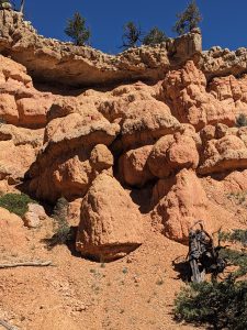
red rock formations.  Dixie National Forest Powell ranger District includes a large red rock canyon and they have developed a nice network of trails to explore it.  It is kind of a mini version of the Utah National Parks, beautiful and amazing to look at and with maybe 1/10th the visitor traffic.  We walk about 8 miles total along a loop following Cassidy, Rich and ledge point trails passing through shaded side canyons, out on rocky points, among rock formations and winding through forested sections.  There are more trails but we are feeling done for the day.  If you are passing through on UT 12 heading for Bryce or Zion, it is worth at least a quick stop.

10,000 ft +

Today we are off to Cedar Breaks National Monument.  We have managed to skip by here all other times through the area and are curious to see this place that exists entirely above 10,000 feet.  Here and at the adjacent Brian Head we are at the highest point of the Grand Staircase, the geologic formation built from ages of sediment laid down by shallow seas, thousands of feet of volcanic ash, multiple lava flows, gigantic fault shifts and centuries of erosion.  
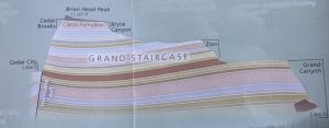
Mother Nature works on an absolutely amazing scale!    Here, we look down into a 3 mile across, 2000-foot-deep bowl with multiple radial ridges like spokes of a wheel all adorned with multicolor hoodoos.  Like Bryce but different.

It has been below freezing most nights up here so snow that fell a few days ago is still hanging around.  Trails are snow covered or slick with sticky, icy mud, not exactly what one hopes for when hiking canyon rims trails!  We limit our stops to overlooks.   I build a tiny snowman.  We spot mule deer in one of the high valley meadows.  We are glad we made the stop this time.  I think the rim trail might be fun given warmer drier weather.  Maybe there will be another time.

Bryce Canyon National Park

Our trip into the park yesterday told us that even in October this place is busy mid-day.  So, we set the alarm for 6:45AM.  
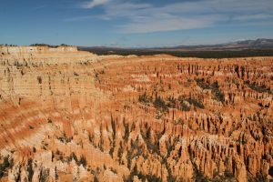
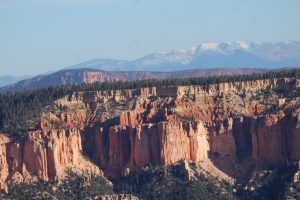
It is in the mid-20s and first light glints off the heavy frost on everything.  Distant mountain tops in all directions sport a new dusting of snow creating a perfect backdrop for fall colors.  Off we go.  We are in the park and at Rainbow point by 9AM.  Parking is no problem, yeah.  We have lots of clothes with us and the sun is toasty.  We set out to explore.

We start with views from the rim beginning at the furthest stop on the scenic drive, Yovimpa and Rainbow Points, then moving in toward the main amphitheater.   Views are absolutely amazing and different from every angle and every stop.  On this far end of the canyon it is all the work of nature.  The hordes of tromping boots are mostly held up on the rim; minimizing trail scars among the hoodoos below. 
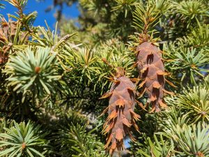
Between the overlooks the bristlecone pine loop takes us past these hardy ancient pines that manage to survive in the cold, wind, scarce water and rocky ground above 9000 ft.  Gnarly, 1000+ years old and amazing.  Check out the namesake cones. We move on stopping at every pull out and taking dozens of pictures.

Now it’s time to wander among the hoodoos.  On the recommendation from the ranger (amazing hoodoos and not many other hikers), we choose the Tower Bridge Trail.  It is short, just 1 1/2 miles each way but it does go to the bottom of the canyon meaning an 800 ft drop in elevation.  It is an out and back; so, yep that’s 800 ft back up.  All this starts at 8000 ft elevation.  We wind among ever changing formations, rocks, spires, castle-like, spiraling walls, and sentinel towers standing solo among the many.  Trail side signs encourage extra care as we make our way through a sensitive vegetation area, another “grove” of bristle cone pines.  Our toes are cramping from the continuous downhill when we reach crisscrossing streambeds, this must be the bottom!  There just ahead, is the Tower Bridge hoodoo.  Definitely castle-tower-like and pretty cool.  
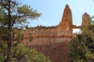
It is absolutely silent here.  What a perfect place for lunch break.  Our pace up is just perfect for admiring lots more hoodoos from differing angles…..Back at the car we log in at 4.89 miles total door to door for this walk and 1095ft elevation change.   Well worth it to get the unique perspective of hoodoos from right among them.

We are back home entertained by the prairie dogs all around us.  There is dinner then a beautiful black night sky.  We fall into bed with the milky way arching across overhead.

Snow-capped mountains to the right and left

We are rolling south on I-15 again, still into the wind, through an unusually cold weather front.  Here in Utah, mountains flanking us east and west are all receiving a new dusting of snow.  It is lovely.  UT 20 winds and climbs through a pass among 10,000 to 12,000 ft peaks to US89 for the last leg of our drive for today.  Our reservations are at Bryce Canyon Springs campground near the tiny town of Hatch between Bryce Canyon NP and Cedar Breaks National Monument.  I call for final directions.  Seems the address and coordinates provided don’t lead to the same place.  Hmmm.  Turns out the address is better, still a bit of wondering as we wander through sagebrush but we do find our way.  The place was a bit over-sold online.  There is no one here for the mandatory check-in and site assignment.  It is a large graveled lot – fenced off from the pasture land thankfully- with some 6 or 8 sites occupied by travel trailers.  They are long level sites.  They are full-hookup (never mind the portable sewer snake at one site).  No bathrooms.  A semi-finished cabin and a “vintage” trailer neither quite occupiable just yet.  But it does work out.  I do have enough cell coverage to remote check in.  We find a suitable site.

White-tailed Prairie Dog

Utah Prairie Dog

We are in the middle of a huge sage brush prairie backed up to mountains with a second snowcapped ridge beyond them.  It is a wild, open-range kind of lovely.  Prairie dogs scurry about, including a threatened sub-species the Utah prairie dog.  Coyotes howl at night and we spot a couple pronghorn.  It is going to be just fine.

It rains off-and- on all evening and we get a surprise, sleet.  Temps at night are to dip into the low 30s or even 20s.   We have power, that means heated mattress pad and an electric heater, we are good.

It Is a mileage day

After a last minute course correction by our Garmin shortened the route by 45 minutes, we settled in for 9+ hours in the seat covering 520 miles while Kent wrestles with high gusty headwinds much of the way puts us overnighting in the Cabella’s lot in Farmington, UT.   We accomplish our goal; plus, it puts us in a place for our first-time dinner at Mo’Bettah’s, for ‘Hawaii style’ fast food.  We go for sort of sampler plates and wind up trying their sweet smoked pork (kalua pig), teriyaki steak, and signature teriyaki chicken all with lots of rice and of all things, macaroni salad.  Two dinners, way more food than we can finish, and it is delicious.  One doggie bag please.  It is a bit pricey but portions are big.  We could easily have shared one entrée.  The Cabella’s lot is brightly lit and noisy as we head to bed but things quiet down soon and we get a pretty good night’s sleep.

We saw pronghorn along the way!  Always a treat to see.

Apgar Outlook Trail

It is cooler than forecast and greyer than forecast but we are going anyway.  Tomorrow is rainy all day so this is our last day to get some more Glacier hiking in.

We are on the trail about 8:45. Even this late, we start out in fleece, gloves and wool hats.  Today we headed out on a 3.6 mile out and back with 1950 ft elevation gain.  It is rated as difficult, it is.  Mile 1 is pretty flat.  The next 1 ½ noticeably steeper.  We peel off all the warm clothes.  The last mile is loooong, steep switchbacks.  We nearly give up several times but a “one more turn” mantra keeps us moving.  A couple we meet at about 3 miles in brags on the views from the top and grouse on the trail.  Ok, we can do it.  We trudge on and are very pleased when we catch sight of the lookout tower at the top.  We made it.  We can see to the mountain ridge that is the continental divide along Going to the Sun and, with a little off trail maneuvering, Lake McDonald nestled in the valley below. We settle on the lookout walkway to lunch and wait for brighter skies.  That doesn’t happen.  It actually gets darker and cooler and weather radar confirms there is rain around us.  It is much too cool to get wet this far from the truck.  Time to head down.

We take a few knee and ankle breaks; still, the return 3.6 miles goes more quickly than our outbound and we make it back down without even a sprinkle of rain.   We are not sorry we made the trek; but we agree a hike this difficult ought to end at a more spectacular view!  Maybe we just needed a brighter, clearer day to bring out the colors and provide a crisper view of the distant mountains. We will sleep well tonight.

Off to Avalanche Lake

It is a bumpy muddy ride up Going to the Sun Road to the trailhead about 5 miles beyond McDonald Lodge.  Our early start pays off as we get parking in the front row and are on the trail by 7:20AM, just right for a quiet start to the hike. We wind through the colossal cedars along The Trail of Cedars boardwalk, pass a rocky, moss-covered waterfall, follow the sometimes babbling sometimes crashing stream, then turn up and into the dense pines.  It is overcast and the shadowy, towering pines are beautiful but a bit foreboding. The trail is steeper than we anticipated but lovely. 
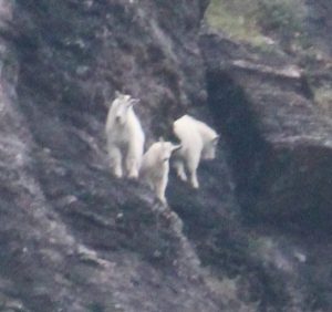
We spot the distinctive white profiles of mountain goats mixed with bright red and yellow fall foliage on the cliffs high above the creek bed.  At about 2.5 miles our path opens onto the foot of Avalanche Lake.   Muted colors of the surrounding mountains and waterside foliage 
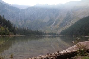
reflect in the still lake waters. A Stellar’s Jay comes begging while we relax on the gravelly beach.  It doesn’t look like it is going to brighten up and it’s getting to be prime hike time, the once peaceful beach is getting busy.  We retrace our steps back to the truck.  This was well worth the walk.

It is still early.  We head on out Going to the Sun toward Logan Pass. Kent has not been on the west side of the divide this trip.  It is hard to capture fall colors with grey skies but it is beautiful.  We are classic Glacier visitors, stopping at pull-offs all along the route scouring the mountains for goats and sheep (we see an impressive looking bighorn ram) and attempting to identify glaciers.  Traffic gets annoying and we turn back toward the west side.  Construction is in full swing, leaving us to wait for the pilot truck and rolling through splattery mud.  There is a car wash in our not-to-distant future.  We make a quick stop for firewood and are back at camp with our feet up.   It’s been a full day.

Finally, real hiking weather

At least “not rainy” weather.  We mess up the alarm so are not up super early but still early enough to start ahead of the crowds.  We have a quick breakfast and load up the backpack for a full day out on the trail.  We load up lots of clothes too, its 42 when we head out the door.  Our destination? Bowman Lake in the north west corner of the park.  The thermometer dips to 36 as we make our way further into the back country. The truck has a pretty good heater though and we stay toasty warm.  Our route includes Outside North Fork Road past Polebridge, the one Carol and I drove last week.  It isn’t any smoother today!  Wild life viewing is pretty good though.  A bevy of ptarmigan scratch and poke along the road’s edge and three elk cows graze peacefully in a roadside meadow.  One crosses not far in front of us as they gradually make their way toward the tree line.

The Open sign at Polebridge Mercantile calls to us, we can’t resist the stop and choose one fresh cinnamon roll and one of those yummy sticky buns.  As we turn to head for Bowman Lake trailhead a paper sign on the Mercantile door catches my eye.  It reads “9/19 to 10/7 bridge over the Flathead closed” “No access to Bowman Lake”.  Surely not, we think as we enjoy our baked treats.  Once finished, we drive the mile or so to the expected crossing.  Sure enough, there stands a flagger and she confirms that there is no access beyond the river.  We (and all the other folks who couldn’t/didn’t believe the sign) make a U-turn and ponder on what to do now.  We decide to drive a bit further north hoping that our wild life viewing luck will continue.   It does not.  We reverse course and bump our way back to Apgar.  The day is still young and we need gas for future wanderings so we head for Hungry Horse where prices are a bit more reasonable, $4.24 vs around $5 in West Glacier.  It is a chance to stop at The Huckleberry Patch too.  Folks in the grocery pointed Carol and I that way for the best locally produced huckleberry treats.  Kent and I split a huckleberry shake.  Didn’t need the sweets but hey, we might not get back this way!

Back home we relax a bit and finalize campgrounds for our move down to Vegas.  It is burgers for dinner and just at dusk we watch a mule deer browse her way across the center of our campground loop.

Carol is off on her own adventures

We get a bit of a lazy start but she is off before noon.

Rain has stopped and an occasional bit of sunshine warms it into the 60s.  We are itching to get out and hike.  We head out to Fish Creek and Rocky Point Trail (Carol and I walked this a few days ago) hoping to get some brighter, sunny lake view pictures.  That doesn’t happen, clouds never really clear; but it is a lovely walk and great to get out and move.   I drag Kent to check out West Glacier then we head back home for a quiet afternoon and evening.  The plan, a campfire tomorrow evening.