The Giant Sequoias of Mariposa Grove

80 degrees under a brilliant fall sun, that’s a lot different than the last time we walked the grove. That stroll involved scaling snow drifts and skating across icy patches.

All the big guys are still here: The Grizzly Giant. Big Grizzly Tree Comp_9468The Bachelor and Three Graces.  A walk-through tunnel tree.  Lots more.  We started off on the tram tour.  The commentary along the way adds a lot to the experience.  We hiked some too. There is something to be said for quiet time among the trees as well.  This place has a soul.

Photo class

Kent took the opportunity to get some instruction from the Ansel Adams Studio on digital photography.  While all the terminology is the same, there are substantial differences and capabilities between film and digital photography.  The future will tell if the instruction makes a substantial difference in the end product but, he now has a better understanding of the capabilities of his digital camera.  It was a fun afternoon.

Soaking it in from the valley floor

Strolling and sitting. Studying intently, sometimes even through binoculars.  Taking it in almost passively just letting the eye wander from soaring heights of Yosemite Falls (bone dry by the way) and Cathedral Mountain to the river side meadows cradling the meandering river.  The common place deer, woodpeckers, jays, and ravens, and the rarer, mama black beer and her cubs shared my day.  It does for the brain and the spirit what a hot tub soak does for the body.   I highly recommend it.

Yosemite from on high

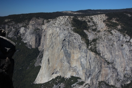
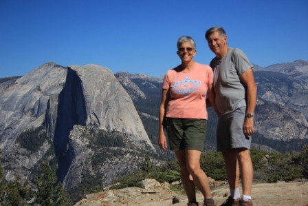
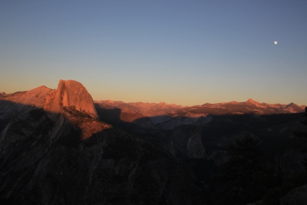
We found ourselves perched on the towering cliffs of the south wall of Yosemite Valley.  From Taft Point, El Capitan and Cathedral Spires towered as our equals in the brilliant sun.  From Sentinel Dome we got a bird’s eye view of Half Dome against a clear blue sky.  Glacier Point provides that perfect perspective for a breathtaking Half Dome at sunset.


The trek to the views is an experience itself.

The Taft Point trail starts out pretty benign; a quiet walk through, fragrant, shade cooled, thick forested terrain with enormous granite boulders scattered about where ancient glaciers lay them. Step out from among the trees and emerge on a rugged, sun baked point.  El Capitan from taftPoint Comp_9061
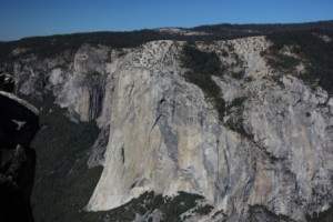
It’s clear where the trail leads, out to the edge of the cliffs that mark the valley walls.  Along the way great fissures give glimpses into the depths below.  At the cliffs edge I had to kneel down to be brave enough to peek over.  The world is huge from here.

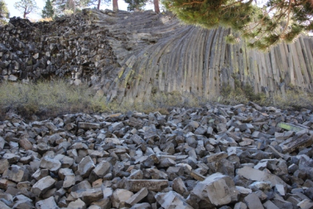
Sentinel Dome is one of a handful of smooth topped granite monoliths that bring a special character to Yosemite landscape.  HalfDome from Sentinel Point Comp_9108 By the way, you’ll find that they aren’t really all that smooth when you set foot on them.  They are spaulding off layers like an onion peeling and pretty irregular under foot.  Steep switch backs followed by a breath robbing clamber up the actual dome are rewarded with views, especially of Half Dome, not possible from the valley floor.


Glacier Point is a bit easier to experience. It is a ¼ mile walk from the parking lot to a perfectly Sunset Hdome Glacier Point Comp_9134
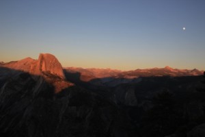
situated overlook that has long been enjoyed as an ideal place for a Yosemite sunset.  Today’s sunset was not spectacular yet still amazing in the way the ever changing light bounces off rock and sky to illuminate entire distant mountain chains as well as the nearer Half Dome.


A charter bus from Illinois had a bit of a rougher Glacier Point experience.  The driver attempted a turn-around, got stuck in the loose sand, and hung high center cross-wise of the road.  There it sat when we emerged from our hike to Sentinel Dome around 4PM and it was still mired in the sand as we headed down after sunset.  Passengers all the while cooling their heels.  The 1st tow truck to arrive managed only to pull off their front bumper.  A larger truck was on its way…estimated to be 2 ½ hours out.  Bummers!
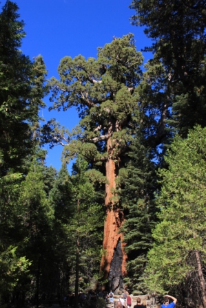
A little grove of Big Trees

I am not sure we actually found the Merced Grove but the hike took us through wonderfully quiet, lush forest with enormous Sequoia trees sharing the company of more kinds of evergreens than I can name. It seems impossible that one could miss a grove of giant sequoia but this one is small (just 20 trees) and way off the beaten path.  Whether we found it or not, what we did see was amazing and well worth the mileage.

Approaching Yosemite from the east

Our upward climb peaks at 9985 ft as we cross Tioga Pass then navigate the ridges on CA120.  From our high perch, colossal granite domes, cliffs, and boulders stand in stark contrast to the deep green of pines.  The rugged landscape is interspersed with lush meadows traced by meandering streams.  Trails take off through the wilderness but we are just observers today.

Just over 9700 feet

Wow, switch backs! I’ll blame it on the thin air, I was puffing much of the time.  We worked pretty hard to take in the views high above Lake George and Lake Mary.  The destination was actually Crystal Lake.  Crystal Lake Comp_9007It is a clear alpine lake perched at just below 9800 feet.  Fall color is just starting here but it was still beautiful nestled among craggy peaks.

Devils Postpile National Monument

A corner carved out of the NF; it is just a pile of rocks, but oh so cool. Slowly cooled lava created perfectly ordered columnar basalt.devils Postpile comp_8860  The octagonal stone pillars are tightly organized and have been cut through by ages of glaciers and water.  It is much like the huge formation at Devils Tower in Wyoming but here a trail runs close enough to see the bundles of ends that look like honey comb and to walk on exposed ends that look like octagonal tiles.  Columns are straight and some bent.  What a great place for a geology (and thermodynamics) lesson.   An American Dipper made an appearance in San Joaquin River that runs along the trail.


Down river we checked out Rainbow falls. Rainbow falls comp_8926Even in this dry season it was beautiful as the flow crossed faceted rock face and fell some 100 feet.  The river creates a surprising oasis among the bare rock and sand.  The trail to the falls passes through an eerie landscape of rock and the skeletons of thousands of tree trunks snapped off at maybe 20 feet above the ground.   A huge blow-down with winds greater than 150 mph tore through this river valley in 2011 and took down everything in front of it.  They are still working to clear campgrounds and trails.

We trekked into the Ansel Adams Wilderness a bit and crossed the Pacific Crest and John Muir Trails. This would be some pretty challenging back country hiking.

National Forest Scenic Area

The Mono Basin within the Inyo National Forest was the first area to be classified as this type of preservation area.  What is it protected from you ask?  LA, they have been siphoning off fresh water from inlet springs since the 40s.  The lake level dropped over 40 vertical feet and was still falling when the protections were put in place.  It will likely never return to its previous level since LA still diverts a considerable flow but it is at least stabilizing.


A vast alkaline lake stretches across the sagebrush covered floor at this west edge of the great basin. IMono Lake Comp_8776t covers 60 square miles with water 2 ½ times as salty as the oceans.  Only brine shrimp and alkali flies make it their full time home but thousands of migrating birds stop here to refuel as they head south for the winter.  The migratory importance and some really weird chemistry are the main reasons it is now protected.


Calcium rich spring waters bubble up through the floor of the lake and combine with the mineral laden lake water to createToufa Comp_8724 limestone crystals that gather in eerie structures that look a lot like coral or stalagmites. When the lake level drops the towers become visible along the shore.  They are fascinating.


The alkali flies are something only the birds could love. Claim is that a band several feet wide and inches deep circles the shore during peak hatch.  There are comparatively few now, fortunately.  Evidence is that early Indians dried them and ate them; they taste like buttery rice.  Ugh!  Nowadays gulls scoop them and grebes, phalenthrope, and ruddy ducks pick they from the salty waters.


This is still volcanic country with lots of cinder cones. Some formed underwater, others into the air.  They make for great vantage points to survey the valley and snow capped mountains that encircle it.

A bit of everything here

The Inyo National Forest stretches along 395 through the Great Basin through miles of sagebrush and acres of lush forest along the mountain flanks.  It includes the largest stand of Jeffries Pines in North America.  Clear cold lakes are fed by year round snow caps.  There is lots of hiking and interesting geology.  We barely samples all there is to do.  Bring lots of clothes though, this is a place of desert temperature swings.  We woke to 27F and found 80F with blistering sun midday.