Mail forwarding snaffu

So, our stop to pick up mail yesterday in Georgetown, ID didn’t work out so well.  It was not there and the postmaster couldn’t tell us where it was or when it might get there.  Fast forward, Kent called this morning and eureka, it is indeed there, just 145 miles back to pick it up.  That is how we are going to spend today!  Just out of camp we see two fawns scrambling to find Mom as we roll by.  It is cloudy with intermittent showers so not a great hiking day anyway and the drive back across the Caribou Mountains is lovely.  We grab lunch at Main Street Diner in Soda Springs and find “square” ice cream in Palisades, close enough to maybe try it again during our stay.  Grizzly paws is huckleberry ice cream with chocolate chunks.  Moose tracks sweet vanilla with caramel, chocolate and nuts.  All in all, not bad for an errand day!  Oh, we did get our mail.

Moving day

We have been at a rather remote, no-services site for 11 days and are heading for another similar situation for the next 2 weeks.  Moving is a bit of a circus: Kent slowly waddles the motorhome out the 10 miles of wash boarded, potholed forest route, we stop to pick up (Not) our forwarded mail, we have run out of propane so there is that stop, no dump station in either camp so a stop along the way for that, and I hit the grocery to restock our kitchen.  We even squeeze in a shower and Kent tops off tanks.  We need every drop to make it 2 weeks between fill and dump stops.  Now we are on our way.

We meet the road grader on the road into Falls campground.  Looks like the drive will be much smoother here and camp is only 2 miles from paved road.  It’s a tight fit in our site but we get situated and look forward to exploring.  Camp is right along the wide, braided Snake River.

Clear Creek

The trail follows the slope of Clear Creek up through a heavily forested ravine.  The sound of water tumbling across rocks is our near-constant companion.  My kind of trail!  We start with a creek crossing then move into heavy aspen and willow so thick and untamed that it is encroaching on the trail.  We don’t have any trouble following the path but the vegetation is wet and we are now too.  We break out the raincoats when a light rain moves in but continue to move up along the creek.  The rain stops as quickly as it began.  Aspens have thinned and we are surrounded by pines now.  Scat and animal tracks confirm that wildlife appreciates this area too.  It looks like we’re moving through the home of moose, elk, deer, bear, and probably fox.  We come upon scattered forest clearings where tall grasses are dotted with a rainbow of wildflower colors.  Woodland birds dart about rarely stopping long enough to even attempt identifying them. Kent does get a good look at this Western Tanager.  It is getting muddy and badly eroded making it hard on the ankles.  We turn back after 2 ¾ miles. It has been a good morning.

Thank you to the gentleman at the Montpelier District Ranger Station.  He recommended this hike as a foot trail only, quiet and through an area frequented by wildlife.

Raspberries

Huckleberries are the Utah State fruit but raspberries are the claim to fame for a nearby town, Garden City.  The annual Raspberry Festival is today and we’re going to be there.  The primary attraction, “The Best” raspberry shakes.  We pass through Paris and make another stop at Donut El Camino.  Our last visit the locals were all about the cinnamon rolls which were not yet out of the oven that day.  Today they are ready and they are huge, gooey, cinnamon-y and still warm from the oven.  Yum

On to the festival.  Turns out its mostly a giant craft market with a handful of food trucks.  There is entertainment but it’s not really to our liking.  We make a pass through and I am tempted at a couple booths with cool grand-daughter items.  Ultimately, I leave empty handed.  New to us, their midway is actually all inflatables: bounce houses, slides, a ninja warrior arena and similar.  Kids are having a great time.  One real miss, they don’t have the boldly advertised raspberry shakes.  Bummer.  Our solution, we go to the local burger place.  They have a thick, rich version that makes a great ending for the afternoon.


Touring the Blackfoot Valley

We are just on our way and spot a young bull elk near the tree line.  He’s a regal looking fellow even though the rack is still in velvet. What a great start to the day.

We head on.  Rolling green fields for as far as one can see splash up the distant mountain slopes, the color interrupted by the grey, green, black and rust of scattered rocky outcroppings.  This area was sculpted by volcanic activity.  An enormous basalt layer laid down long ago has been broken and bulged by subterranean lava flow and expansion.  The result is piles of rubble in some places, sunken depressions and smooth domes in others.  Years of erosion has made for fertile soil and it all somehow holds on to rainfall to create fantastic farmland.  Greens range from the bright new growth of planted grain through grey green of sagebrush to the deep green of pines on the mountainsides; all mottled and swirled together.  Today the shadows of thunderstorm driven clouds add another layer to the color scheme.  Blackfoot Reservoir lies in stark contrast to it all.

We go beyond the reservoir to Gray’s Lake NWR.  It is really a giant marsh with limited areas of open water and scattered islands of higher ground.  Today I am on the hunt for their largest claimed resident, moose.  There are sandhill cranes and many hawks plus Canada geese and a nice sampling of ducklings and baby grebes; but, no moose.

The rain that has been threatening all day catches us as we wrap things up and head home.

New Shoe

Kent is off to get the new tire.  I am working on a vacation countdown calendar to send to Willa and Hazel.  We are down to three weeks until they meet us in the Tetons.  We can’t wait.

The sheep are back, at least quite a few of them.  Kent spotted them scattered along our access road while out on his errand.

Logan Canyon

The Logan River cuts through the mountain ridge just west of Bear Lake across to Logan UT.  US 89 shares the rocky canyon with the roaring waters on the way through Cache National Forest. It is a pretty drive especially toward the rugged cliffy end near Logan.  I am surprised at the number of private homes tucked along the route.  It seems like Utah has pretty loose property laws when it comes to private use of public lands?  We spend a few exploring Logan then it’s on back home.  We manage to rack up 200 miles today without really going anywhere.

We close out the day with a stop at Papa’s Chocolates and Ice Cream in Montpelier.  The chocolates all sound wonderful but my craving is for ice cream.  They serve Aggie ice cream.  Locally made at the University of Utah in Logan and they just got in a shipment.  There are lots of flavors.  I go for raspberries and cream in a store made waffle cone.  Kent goes for the waffle cone too.  His is filled with a chocolatey version with caramel chunks, Moose Buns I think it’s called.  The cones are super crunchy and ice cream wonderfully creamy.  Delicious.

Jack’s pizza

We passed through Logan at lunch time and stopped at Jack’s wood-fired Oven Pizza.  The pizza is pretty traditional thin crust but with house-made Italian sausage and pickled jalapenos.  We splurge on appetizers, a pesto artichoke stuffed portabella with asiago and balsamic drizzle and “lyon bread”, their take on cheese garlic bread.  Both are delicious, and our doggie bag provides plenty of leftovers for dinner.

Wildlife Refuge and a bit of history

An early one today.  We are up at 5:30 heading to Bear Lake NWR to see who is hanging out in this huge bullrush marsh.  We take the auto loop, there are mosquitos here too.  We spot the usual wetland suspects, redwing blackbirds, the slightly less frequent yellow headed blackbird, coots, mallards and a couple osprey.  It is a breeding area for coots and ibis as well as for Canada geese and mallards.  There are plenty of mommies with their broods trailing behind.  Nothing spectacular but a nice morning.

We swing through Paris, ID 
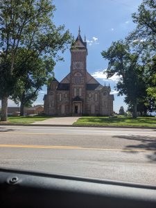
and check out the 1889 LDS Tabernacle and a number of historic buildings along Main Street.   One of the buildings houses Donut El Camino.  We just have to stop.  Tin ceiling, a beautiful old hardwood floor, and at least three woodburning stoves (none are needed today) make for a wonderfully laid-back place to hang out.  The donuts and coffee make it well worth the stop.   It appears the proprietors live in an open upstairs loft.

Then comes the history part, The Oregon/California Trail Center in Montpelier.  The main floor is devoted to the story of those who traveled through Idaho on this trail.  The count was around 450000 persons between 1840s and 1870s, 10% didn’t make it.  In a small-scale indoor re-enactment, a wagon driver and two young women travelers tell the story of hardship and perseverance.  Well done.

Upstairs we find the work of local artisans on display and for sale.  There is a large quilt show going on as well.  What a wonderful space to showcase their work.

The lower floor is a classic small-town museum like those we have seen all across the country.  It is filled with stuff people kept and donated or loaned to represent their home town, Montpelier (Oregon Trail stop Clover Creek). As always, it’s fun to check it out.

We are heading out and a fellow steps out of the back kitchen to say, “let me show you something.”  He leads us into this cool event space.  Booths are set up as covered wagons and set in a circle.  Each wagon has a screen where they project photos telling the story of the trail journey.  They routinely entertain tour buses but also host local events of all sorts.  It looks like it could be a fun space.  He is obviously very proud of it.

Today, an Idaho traffic jam.  A herd of sheep is lounging in the shade along the gravel forest route not far from camp.   Fortunately; they and their trusty herd dog (a somewhat scruffy looking Great Pyrenees) are very interested in shade.  They are mostly roadside and we are able to get by without much difficulty while only slightly disturbing the dog.  Parked mostly out of sight, we spot a home-made trailer/shack on wheels that we saw much further out in the forest yesterday.  We surmise they are all coming down for shearing or counting or heaven forbid, culling.  There are lots of lambs.
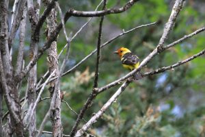
A “captive” geyser

A neighbor in camp suggests we take the scenic route up through Caribou National Forest to Soda Springs to check out their geyser.  The road is gravel and graded dirt but not bad and the route is through rolling meadows mixed with thick stands of pine. It is ranch country.  Cattle are the main “wildlife” but we do see a golden eagle, a bald eagle, and the most unusual for us, a badger.  I guess they are pretty common but it is a rare sighting for us.

We get into to town just in time to see the geyser.  It erupts on the hour every hour for six minutes.  
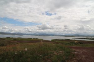
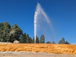
How can they be so precise?  It is actually an artesian spring that they have capped and put a solenoid valve on….tada, very predictable.  It has been a tourist attraction since in 1937 a couple of fellows looking to tap a spring for a swimming pool hit a gas pocket and blew out the spring.  It flooded the town a couple days then all agreed it had to be plugged.  Not long after, the “captive” geyser attraction was born.  It is cool.

There is another spring in town, Hooper Spring. It is naturally flowing mineral water that emerges into a protective stone spring house providing all who wish the opportunity to sample its healing waters.  We do.  It tastes salty but not bad.  The local thing seems to be to bring a water bottle and powdered flavoring and make your own soda.   Must be ok, lots of kids are sipping it.

Soda Springs was also a site 
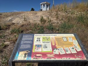
for the Ground Observer Corp in the 1950s.  We checked out a reproduction of the little kiosk volunteers manned to watch the skies to alert of any foreign incursion into US airspace.  There is report of one false alarm that got a domestic flight grounded but no evidence of any actual threat to national security.  Still, it is an obviously proud civic memory.

Lunch at A&W then we take the shorter, highway route back home.

Darn, another equipment problem.  We are maybe two miles from camp and the low-pressure indicator comes on.  Just annoying at first but we watch the pressure drop like a rock.  Within a couple minutes it reads 0.  Gotta stop, right here along the gravel road.  We have to get the user’s manual out to figure out the jack and the spare tire hanger but all is done in 10 minutes and we are safely home.  There is a big jagged hole right in the middle of the tread.  Looks like a new tire in our near future.

Higher ground – and cooler air

Ok, back up into the mountains.  We are heading for Summit View campground in Caribou Targhee National Forest above Soda Springs ID.   Highs in the mid-80s and nights in the 50s, Ahhhh.  In Jensen and Vernal we pass all manner of dinosaur statue and sculpture.  Whimsical to true-to-life-fierce they stand watch at business, playgrounds, and city halls.  Beyond town, the route from the National Monument passes through more of the dinosaur valley with signs along the way reminding us what layer of rock we are passing through and who/what lived there at the time it was deposited.  Then we wind along Flaming Gorge, rugged with pines standing in contrast to the redrock.  Things level out and we glide though wide rolling valleys with grasslands as far as we can see either way
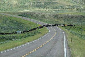
.  We experience a Wyoming traffic jam.  Four cowboys on horseback moving a herd of cattle across the road….they didn’t all want to go that way!   We turn west on I80 and things get less scenic.  We are crossing broad alkali flats dotted with mines and wells and crisscrossed by railroad tracks and gravel roads carrying a steady flow of huge dump trucks.  There are signs warning of road closures while traffic waits for quarry dynamite explosions.  It seems like even this barren arid land deserves better treatment than this.  Probably not going to happen though, these minerals and compounds are used in a lot of stuff we consider essential.  Turning west and north into Idaho we first find lush irrigated farmland including brilliant yellow fields of flowering canola plants.  Soon we are in pine covered mountains and find our way to camp.  It is pretty remote with the nearest town with any sort of services over 25 miles away.  No cell service at all in camp.  It is cool and beautiful here.  Tomorrow, we head out to explore.

We had our first hick-up towing the pick-up.   The battery was dead when we unhooked.  No big problem, we just jumped it with the motorhome.  Still, it was odd.  We found no obvious reason for the problem.