
We head out today for the first of two stops to explore the high mesas of central/western Colorado. The area is sparsely populated and nearly all designated as National Forest. We make our way along US50 west again, in the motorhome this time, to cross Monarch Pass and on to Gunnison where we turn on to county and forest routes. The last 17 miles climb Taylor Canyon sharing the tree-shrouded route with the Taylor River. We settle in then set out to explore on up the canyon to Cottonwood Pass.
Turns out I missed a detail or two in my planning research. First, this entire national forest corridor has been specifically designed for off road vehicle recreation. Everything from dirt bikes to quads to full size off-road vehicles can run these trails. The word to hikers, watch out! Had I known, we likely would have steered clear. But, here we are. Second, lots of online sources describe the road to Cottonwood Pass as rugged, high clearance, 4-wheel drive only. Not! The entire distance is now paved.
On up to Cottonwood Pass. 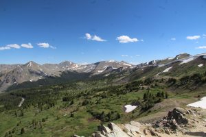 There are switchbacks and hairpin curves and quite a bit of traffic but the drive is lovely and pretty easy. We are in the Sawatch Range and the pass is at 12,119 ft elevation, the highest paved crossing of the continental divide in the US. We hike up another couple hundred feet to an amazing view on a trail that winds through a wildflower covered alpine meadow. It is beautiful in every direction. Trails go on from here but we hang for a bit then head back down then to camp for a quiet evening. The host says there was a bear in camp last week. I’ll believe it when I see it!