The Mono Basin within the Inyo National Forest was the first area to be classified as this type of preservation area. What is it protected from you ask? LA, they have been siphoning off fresh water from inlet springs since the 40s. The lake level dropped over 40 vertical feet and was still falling when the protections were put in place. It will likely never return to its previous level since LA still diverts a considerable flow but it is at least stabilizing.
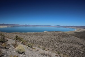
A vast alkaline lake stretches across the sagebrush covered floor at this west edge of the great basin. I t covers 60 square miles with water 2 ½ times as salty as the oceans. Only brine shrimp and alkali flies make it their full time home but thousands of migrating birds stop here to refuel as they head south for the winter. The migratory importance and some really weird chemistry are the main reasons it is now protected.
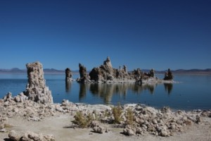
Calcium rich spring waters bubble up through the floor of the lake and combine with the mineral laden lake water to create limestone crystals that gather in eerie structures that look a lot like coral or stalagmites. When the lake level drops the towers become visible along the shore. They are fascinating.
The alkali flies are something only the birds could love. Claim is that a band several feet wide and inches deep circles the shore during peak hatch. There are comparatively few now, fortunately. Evidence is that early Indians dried them and ate them; they taste like buttery rice. Ugh! Nowadays gulls scoop them and grebes, phalenthrope, and ruddy ducks pick they from the salty waters.
This is still volcanic country with lots of cinder cones. Some formed underwater, others into the air. They make for great vantage points to survey the valley and snow capped mountains that encircle it.
